You are here: Home > Network List > TA - USArray Transportable Network (new EarthScope stations) Stations List
> Station H31M Peel River, Yukon, CAN > Earthquake Result Viewer
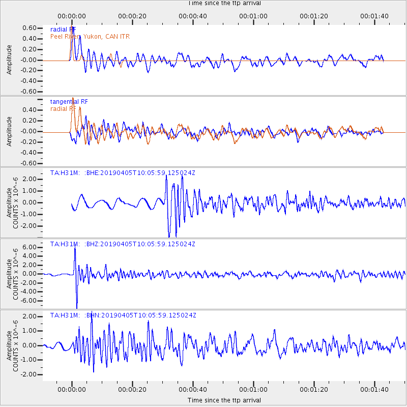
H31M Peel River, Yukon, CAN - Earthquake Result Viewer
*The percent match for this event was below the threshold and hence no stack was calculated.
| Earthquake location: |
Southeast Of Honshu, Japan |
| Earthquake latitude/longitude: |
30.4/138.6 |
| Earthquake time(UTC): |
2019/04/05 (095) 09:56:53 GMT |
| Earthquake Depth: |
389 km |
| Earthquake Magnitude: |
5.8 Mww |
| Earthquake Catalog/Contributor: |
NEIC PDE/us |
|
| Network: |
TA USArray Transportable Network (new EarthScope stations) |
| Station: |
H31M Peel River, Yukon, CAN |
| Lat/Lon: |
65.81 N/134.34 W |
| Elevation: |
642 m |
|
| Distance: |
61.5 deg |
| Az: |
27.94 deg |
| Baz: |
280.956 deg |
| Ray Param: |
$rayparam |
*The percent match for this event was below the threshold and hence was not used in the summary stack. |
|
| Radial Match: |
57.51034 % |
| Radial Bump: |
400 |
| Transverse Match: |
64.745964 % |
| Transverse Bump: |
400 |
| SOD ConfigId: |
13570011 |
| Insert Time: |
2019-05-02 21:22:10.022 +0000 |
| GWidth: |
2.5 |
| Max Bumps: |
400 |
| Tol: |
0.001 |
|
Signal To Noise
| Channel | StoN | STA | LTA |
| TA:H31M: :BHZ:20190405T10:05:59.125024Z | 11.93472 | 2.5530812E-6 | 2.1392049E-7 |
| TA:H31M: :BHN:20190405T10:05:59.125024Z | 2.853494 | 5.591333E-7 | 1.9594691E-7 |
| TA:H31M: :BHE:20190405T10:05:59.125024Z | 4.699977 | 1.5060148E-6 | 3.2043025E-7 |
| Arrivals |
| Ps | |
| PpPs | |
| PsPs/PpSs | |


