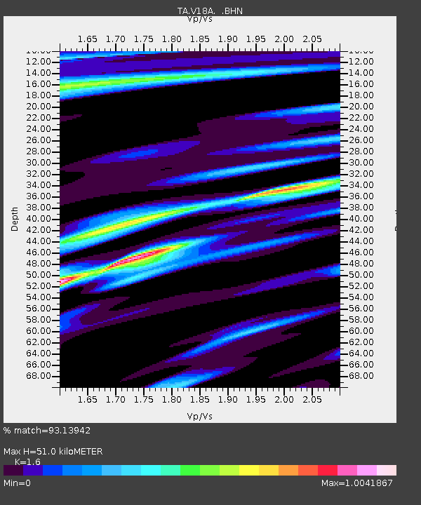
V18A Ganado, AZ, USA - Earthquake Result Viewer
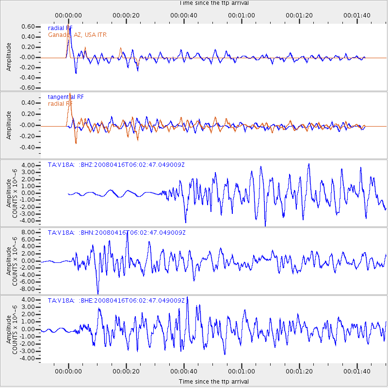
Earthquake location: Andreanof Islands, Aleutian Is.
Earthquake latitude/longitude: 51.9/-179.2
Earthquake time(UTC): 2008/04/16 (107) 05:54:19 GMT
Earthquake Depth: 13 km
Earthquake Magnitude: 6.1 MB, 6.5 MS, 6.6 MW, 6.6 MW
Earthquake Catalog/Contributor: WHDF/NEIC
Network: TA USArray Transportable Network (new EarthScope stations)
Station: V18A Ganado, AZ, USA
Lat/Lon: 35.71 N/109.93 W
Elevation: 1977 m
Distance: 50.6 deg
Az: 80.027 deg
Baz: 311.391 deg
Ray Param: 0.06794722
Estimated Moho Depth: 51.0 km
Estimated Crust Vp/Vs: 1.60
Assumed Crust Vp: 6.496 km/s
Estimated Crust Vs: 4.06 km/s
Estimated Crust Poisson's Ratio: 0.18
Radial Match: 93.13942 %
Radial Bump: 400
Transverse Match: 82.32242 %
Transverse Bump: 400
SOD ConfigId: 2504
Insert Time: 2010-03-06 21:20:30.181 +0000
GWidth: 2.5
Max Bumps: 400
Tol: 0.001

Signal To Noise

ChannelStoNSTALTA
TA:V18A: :BHN:20080416T06:02:47.049009Z5.656049.871693E-71.7453364E-7
TA:V18A: :BHE:20080416T06:02:47.049009Z1.13042992.566987E-72.270806E-7
TA:V18A: :BHZ:20080416T06:02:47.049009Z1.06593182.9355172E-72.7539446E-7
Arrivals
Ps5.0 SECOND
PpPs19 SECOND
PsPs/PpSs24 SECOND