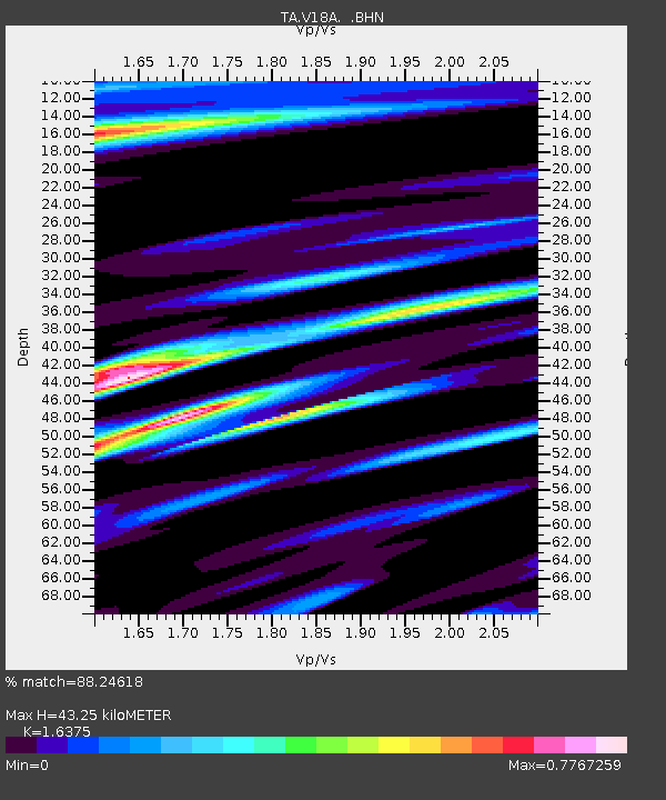
V18A Ganado, AZ, USA - Earthquake Result Viewer
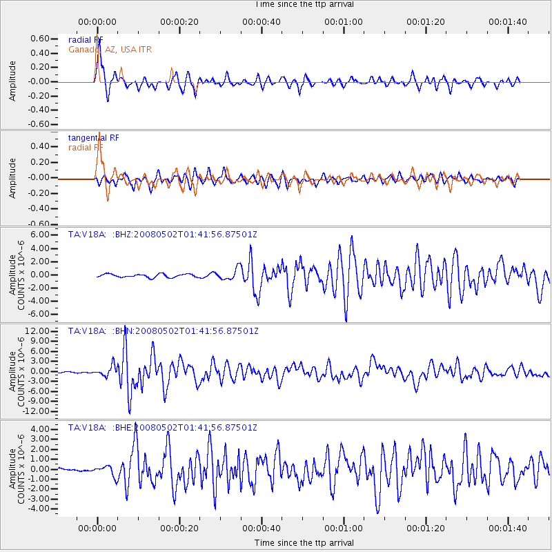
Earthquake location: Andreanof Islands, Aleutian Is.
Earthquake latitude/longitude: 51.9/-177.5
Earthquake time(UTC): 2008/05/02 (123) 01:33:37 GMT
Earthquake Depth: 14 km
Earthquake Magnitude: 6.3 MB, 6.8 MS, 6.6 MW, 6.6 MW
Earthquake Catalog/Contributor: WHDF/NEIC
Network: TA USArray Transportable Network (new EarthScope stations)
Station: V18A Ganado, AZ, USA
Lat/Lon: 35.71 N/109.93 W
Elevation: 1977 m
Distance: 49.6 deg
Az: 81.161 deg
Baz: 311.157 deg
Ray Param: 0.068593435
Estimated Moho Depth: 43.25 km
Estimated Crust Vp/Vs: 1.64
Assumed Crust Vp: 6.496 km/s
Estimated Crust Vs: 3.967 km/s
Estimated Crust Poisson's Ratio: 0.20
Radial Match: 88.24618 %
Radial Bump: 367
Transverse Match: 80.63366 %
Transverse Bump: 400
SOD ConfigId: 2504
Insert Time: 2010-03-06 21:20:31.853 +0000
GWidth: 2.5
Max Bumps: 400
Tol: 0.001

Signal To Noise

ChannelStoNSTALTA
TA:V18A: :BHN:20080502T01:41:56.87501Z11.5054911.5881506E-61.3803414E-7
TA:V18A: :BHE:20080502T01:41:56.87501Z4.06236465.422213E-71.334743E-7
TA:V18A: :BHZ:20080502T01:41:56.87501Z3.44676858.632176E-72.5044258E-7
Arrivals
Ps4.5 SECOND
PpPs16 SECOND
PsPs/PpSs21 SECOND