You are here: Home > Network List > TA - USArray Transportable Network (new EarthScope stations) Stations List
> Station V18A Ganado, AZ, USA > Earthquake Result Viewer
V18A Ganado, AZ, USA - Earthquake Result Viewer
| Earthquake location: |
Easter Island Region |
| Earthquake latitude/longitude: |
-28.9/-112.3 |
| Earthquake time(UTC): |
2008/05/31 (152) 23:16:04 GMT |
| Earthquake Depth: |
10 km |
| Earthquake Magnitude: |
5.5 MS, 5.4 MB, 5.8 MW, 5.8 MW |
| Earthquake Catalog/Contributor: |
WHDF/NEIC |
|
| Network: |
TA USArray Transportable Network (new EarthScope stations) |
| Station: |
V18A Ganado, AZ, USA |
| Lat/Lon: |
35.71 N/109.93 W |
| Elevation: |
1977 m |
|
| Distance: |
64.3 deg |
| Az: |
2.1 deg |
| Baz: |
182.262 deg |
| Ray Param: |
0.05899563 |
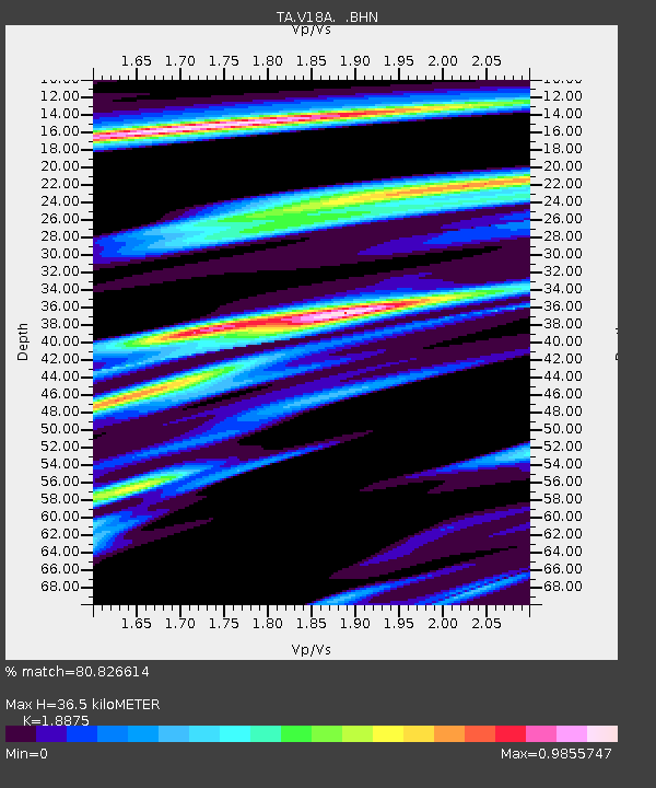
| Estimated Moho Depth: |
36.5 km |
| Estimated Crust Vp/Vs: |
1.89 |
| Assumed Crust Vp: |
6.496 km/s |
| Estimated Crust Vs: |
3.442 km/s |
| Estimated Crust Poisson's Ratio: |
0.30 |
|
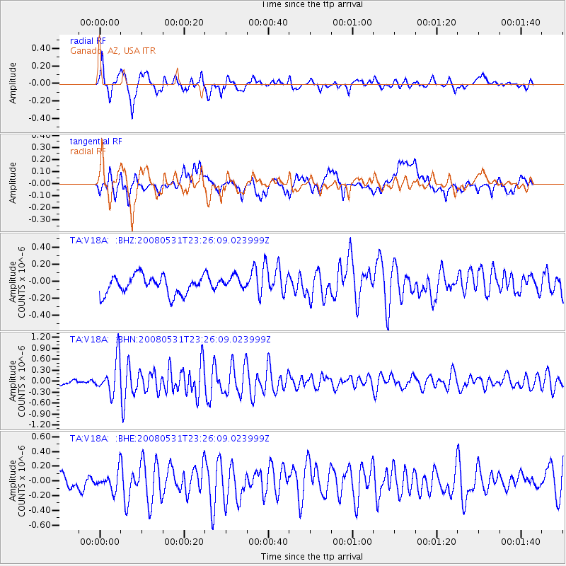
| Radial Match: |
80.826614 % |
| Radial Bump: |
400 |
| Transverse Match: |
65.98493 % |
| Transverse Bump: |
400 |
| SOD ConfigId: |
2504 |
| Insert Time: |
2010-03-06 21:20:33.820 +0000 |
| GWidth: |
2.5 |
| Max Bumps: |
400 |
| Tol: |
0.001 |
|
Signal To Noise
| Channel | StoN | STA | LTA |
| TA:V18A: :BHN:20080531T23:26:09.023999Z | 7.1258097 | 4.926982E-7 | 6.914277E-8 |
| TA:V18A: :BHE:20080531T23:26:09.023999Z | 1.6960473 | 1.3868531E-7 | 8.176972E-8 |
| TA:V18A: :BHZ:20080531T23:26:09.023999Z | 0.74507964 | 8.016271E-8 | 1.0758945E-7 |
| Arrivals |
| Ps | 5.2 SECOND |
| PpPs | 16 SECOND |
| PsPs/PpSs | 21 SECOND |


