You are here: Home > Network List > TA - USArray Transportable Network (new EarthScope stations) Stations List
> Station V18A Ganado, AZ, USA > Earthquake Result Viewer
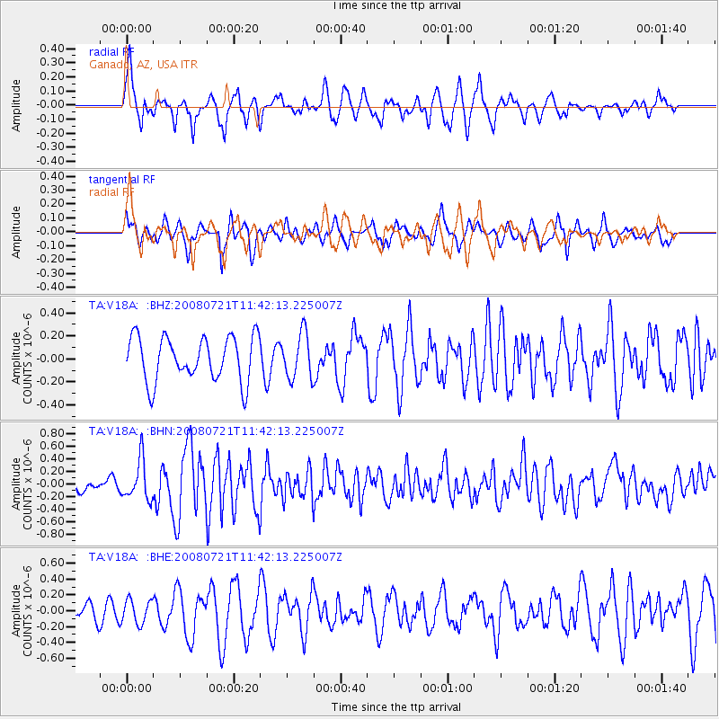
V18A Ganado, AZ, USA - Earthquake Result Viewer
*The percent match for this event was below the threshold and hence no stack was calculated.
| Earthquake location: |
Off East Coast Of Honshu, Japan |
| Earthquake latitude/longitude: |
37.2/142.1 |
| Earthquake time(UTC): |
2008/07/21 (203) 11:30:29 GMT |
| Earthquake Depth: |
22 km |
| Earthquake Magnitude: |
5.7 MB, 5.6 MS, 6.0 MW, 5.9 MW |
| Earthquake Catalog/Contributor: |
WHDF/NEIC |
|
| Network: |
TA USArray Transportable Network (new EarthScope stations) |
| Station: |
V18A Ganado, AZ, USA |
| Lat/Lon: |
35.71 N/109.93 W |
| Elevation: |
1977 m |
|
| Distance: |
81.4 deg |
| Az: |
51.501 deg |
| Baz: |
309.825 deg |
| Ray Param: |
$rayparam |
*The percent match for this event was below the threshold and hence was not used in the summary stack. |
|
| Radial Match: |
63.88981 % |
| Radial Bump: |
392 |
| Transverse Match: |
63.6644 % |
| Transverse Bump: |
388 |
| SOD ConfigId: |
2504 |
| Insert Time: |
2010-03-06 21:20:41.611 +0000 |
| GWidth: |
2.5 |
| Max Bumps: |
400 |
| Tol: |
0.001 |
|
Signal To Noise
| Channel | StoN | STA | LTA |
| TA:V18A: :BHN:20080721T11:42:13.225007Z | 3.6382043 | 3.143514E-7 | 8.64029E-8 |
| TA:V18A: :BHE:20080721T11:42:13.225007Z | 1.426442 | 1.4973025E-7 | 1.0496764E-7 |
| TA:V18A: :BHZ:20080721T11:42:13.225007Z | 1.0223836 | 1.9785645E-7 | 1.9352468E-7 |
| Arrivals |
| Ps | |
| PpPs | |
| PsPs/PpSs | |


