You are here: Home > Network List > TA - USArray Transportable Network (new EarthScope stations) Stations List
> Station O19K Port Alsworth, AK, USA > Earthquake Result Viewer
O19K Port Alsworth, AK, USA - Earthquake Result Viewer
| Earthquake location: |
Southeast Of Honshu, Japan |
| Earthquake latitude/longitude: |
30.4/138.6 |
| Earthquake time(UTC): |
2019/04/05 (095) 09:56:53 GMT |
| Earthquake Depth: |
389 km |
| Earthquake Magnitude: |
5.8 Mww |
| Earthquake Catalog/Contributor: |
NEIC PDE/us |
|
| Network: |
TA USArray Transportable Network (new EarthScope stations) |
| Station: |
O19K Port Alsworth, AK, USA |
| Lat/Lon: |
60.20 N/154.32 W |
| Elevation: |
96 m |
|
| Distance: |
52.8 deg |
| Az: |
35.294 deg |
| Baz: |
267.131 deg |
| Ray Param: |
0.06500228 |
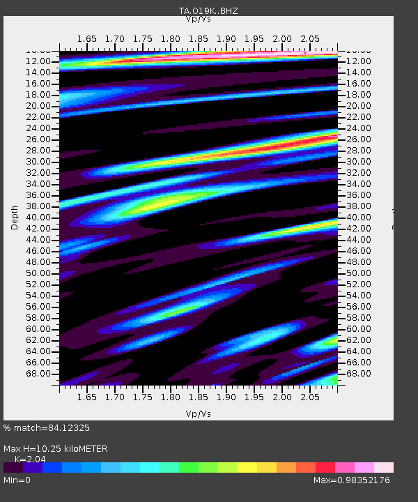
| Estimated Moho Depth: |
10.25 km |
| Estimated Crust Vp/Vs: |
2.04 |
| Assumed Crust Vp: |
6.566 km/s |
| Estimated Crust Vs: |
3.219 km/s |
| Estimated Crust Poisson's Ratio: |
0.34 |
|
| Radial Match: |
84.12325 % |
| Radial Bump: |
375 |
| Transverse Match: |
70.781906 % |
| Transverse Bump: |
400 |
| SOD ConfigId: |
13570011 |
| Insert Time: |
2019-05-02 21:22:56.811 +0000 |
| GWidth: |
2.5 |
| Max Bumps: |
400 |
| Tol: |
0.001 |
|

Signal To Noise
| Channel | StoN | STA | LTA |
| TA:O19K: :BHZ:20190405T10:04:59.200006Z | 16.625973 | 3.7342102E-6 | 2.2460101E-7 |
| TA:O19K: :BHN:20190405T10:04:59.200006Z | 3.203636 | 7.591201E-7 | 2.3695581E-7 |
| TA:O19K: :BHE:20190405T10:04:59.200006Z | 9.11346 | 1.938326E-6 | 2.1268828E-7 |
| Arrivals |
| Ps | 1.7 SECOND |
| PpPs | 4.5 SECOND |
| PsPs/PpSs | 6.2 SECOND |


