You are here: Home > Network List > TA - USArray Transportable Network (new EarthScope stations) Stations List
> Station P17K Kvichak River, AK, USA > Earthquake Result Viewer
P17K Kvichak River, AK, USA - Earthquake Result Viewer
| Earthquake location: |
Southeast Of Honshu, Japan |
| Earthquake latitude/longitude: |
30.4/138.6 |
| Earthquake time(UTC): |
2019/04/05 (095) 09:56:53 GMT |
| Earthquake Depth: |
389 km |
| Earthquake Magnitude: |
5.8 Mww |
| Earthquake Catalog/Contributor: |
NEIC PDE/us |
|
| Network: |
TA USArray Transportable Network (new EarthScope stations) |
| Station: |
P17K Kvichak River, AK, USA |
| Lat/Lon: |
59.20 N/156.44 W |
| Elevation: |
91 m |
|
| Distance: |
51.6 deg |
| Az: |
36.48 deg |
| Baz: |
266.031 deg |
| Ray Param: |
0.06570489 |
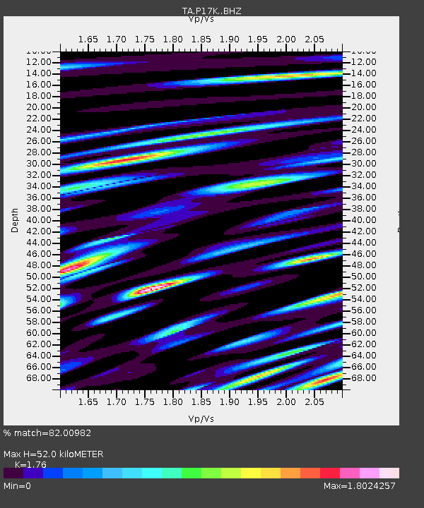
| Estimated Moho Depth: |
52.0 km |
| Estimated Crust Vp/Vs: |
1.76 |
| Assumed Crust Vp: |
6.276 km/s |
| Estimated Crust Vs: |
3.566 km/s |
| Estimated Crust Poisson's Ratio: |
0.26 |
|
| Radial Match: |
82.00982 % |
| Radial Bump: |
400 |
| Transverse Match: |
73.200066 % |
| Transverse Bump: |
400 |
| SOD ConfigId: |
13570011 |
| Insert Time: |
2019-05-02 21:23:01.466 +0000 |
| GWidth: |
2.5 |
| Max Bumps: |
400 |
| Tol: |
0.001 |
|

Signal To Noise
| Channel | StoN | STA | LTA |
| TA:P17K: :BHZ:20190405T10:04:50.975Z | 11.45118 | 4.1449257E-6 | 3.6196494E-7 |
| TA:P17K: :BHN:20190405T10:04:50.975Z | 2.0050292 | 1.4200858E-6 | 7.0826195E-7 |
| TA:P17K: :BHE:20190405T10:04:50.975Z | 4.1797633 | 2.1056903E-6 | 5.037822E-7 |
| Arrivals |
| Ps | 6.6 SECOND |
| PpPs | 22 SECOND |
| PsPs/PpSs | 28 SECOND |


