You are here: Home > Network List > TA - USArray Transportable Network (new EarthScope stations) Stations List
> Station V18A Ganado, AZ, USA > Earthquake Result Viewer
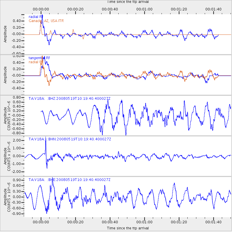
V18A Ganado, AZ, USA - Earthquake Result Viewer
*The percent match for this event was below the threshold and hence no stack was calculated.
| Earthquake location: |
E. Russia-N.E. China Border Reg. |
| Earthquake latitude/longitude: |
42.5/131.9 |
| Earthquake time(UTC): |
2008/05/19 (140) 10:08:36 GMT |
| Earthquake Depth: |
513 km |
| Earthquake Magnitude: |
5.7 MW, 5.4 MB, 5.6 MW |
| Earthquake Catalog/Contributor: |
WHDF/NEIC |
|
| Network: |
TA USArray Transportable Network (new EarthScope stations) |
| Station: |
V18A Ganado, AZ, USA |
| Lat/Lon: |
35.71 N/109.93 W |
| Elevation: |
1977 m |
|
| Distance: |
83.9 deg |
| Az: |
46.169 deg |
| Baz: |
319.042 deg |
| Ray Param: |
$rayparam |
*The percent match for this event was below the threshold and hence was not used in the summary stack. |
|
| Radial Match: |
73.74141 % |
| Radial Bump: |
325 |
| Transverse Match: |
68.00896 % |
| Transverse Bump: |
400 |
| SOD ConfigId: |
2504 |
| Insert Time: |
2010-03-06 21:20:49.540 +0000 |
| GWidth: |
2.5 |
| Max Bumps: |
400 |
| Tol: |
0.001 |
|
Signal To Noise
| Channel | StoN | STA | LTA |
| TA:V18A: :BHN:20080519T10:19:40.400027Z | 4.6864915 | 7.14698E-7 | 1.5250171E-7 |
| TA:V18A: :BHE:20080519T10:19:40.400027Z | 2.3347518 | 5.010721E-7 | 2.1461472E-7 |
| TA:V18A: :BHZ:20080519T10:19:40.400027Z | 2.0815542 | 3.7186553E-7 | 1.7864801E-7 |
| Arrivals |
| Ps | |
| PpPs | |
| PsPs/PpSs | |


