You are here: Home > Network List > US - United States National Seismic Network Stations List
> Station MSO Missoula, Montana, USA > Earthquake Result Viewer
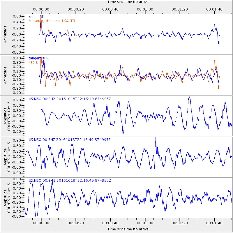
MSO Missoula, Montana, USA - Earthquake Result Viewer
*The percent match for this event was below the threshold and hence no stack was calculated.
| Earthquake location: |
Leeward Islands |
| Earthquake latitude/longitude: |
15.2/-61.5 |
| Earthquake time(UTC): |
2016/10/18 (292) 22:08:14 GMT |
| Earthquake Depth: |
143 km |
| Earthquake Magnitude: |
5.6 MWW, 5.6 MWB |
| Earthquake Catalog/Contributor: |
NEIC PDE/NEIC COMCAT |
|
| Network: |
US United States National Seismic Network |
| Station: |
MSO Missoula, Montana, USA |
| Lat/Lon: |
46.83 N/113.94 W |
| Elevation: |
1264 m |
|
| Distance: |
53.6 deg |
| Az: |
317.437 deg |
| Baz: |
108.013 deg |
| Ray Param: |
$rayparam |
*The percent match for this event was below the threshold and hence was not used in the summary stack. |
|
| Radial Match: |
60.37561 % |
| Radial Bump: |
385 |
| Transverse Match: |
59.70342 % |
| Transverse Bump: |
400 |
| SOD ConfigId: |
1815711 |
| Insert Time: |
2016-11-01 22:15:02.207 +0000 |
| GWidth: |
2.5 |
| Max Bumps: |
400 |
| Tol: |
0.001 |
|
Signal To Noise
| Channel | StoN | STA | LTA |
| US:MSO:00:BHZ:20161018T22:16:49.874995Z | 2.825527 | 4.1801763E-7 | 1.4794325E-7 |
| US:MSO:00:BH1:20161018T22:16:49.874995Z | 0.9315611 | 4.6861186E-7 | 5.030393E-7 |
| US:MSO:00:BH2:20161018T22:16:49.874995Z | 1.9657727 | 3.8669748E-7 | 1.9671526E-7 |
| Arrivals |
| Ps | |
| PpPs | |
| PsPs/PpSs | |


