You are here: Home > Network List > TA - USArray Transportable Network (new EarthScope stations) Stations List
> Station V18A Ganado, AZ, USA > Earthquake Result Viewer
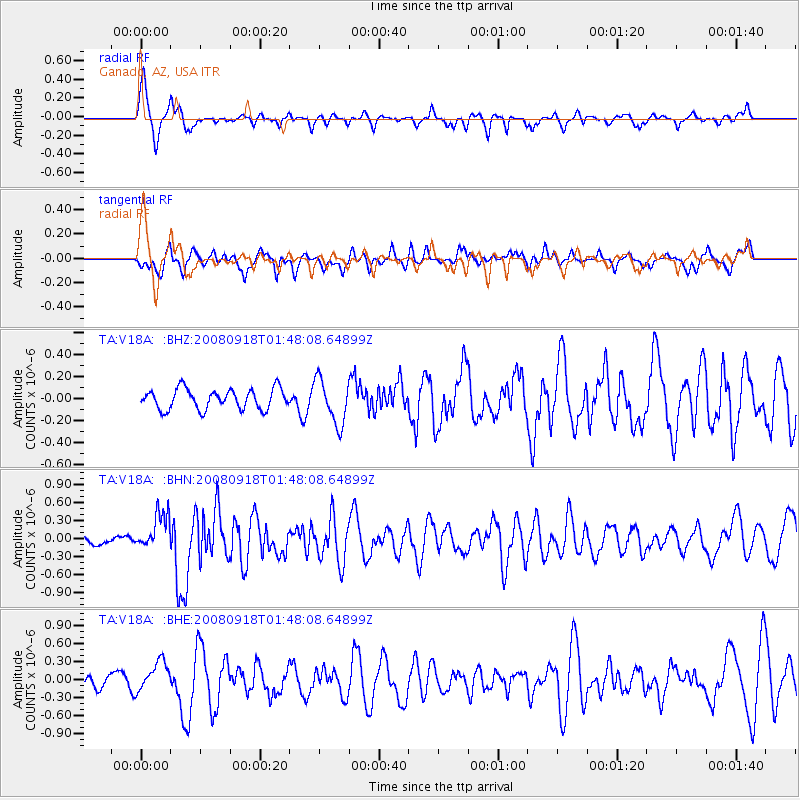
V18A Ganado, AZ, USA - Earthquake Result Viewer
*The percent match for this event was below the threshold and hence no stack was calculated.
| Earthquake location: |
Central East Pacific Rise |
| Earthquake latitude/longitude: |
-4.6/-106.0 |
| Earthquake time(UTC): |
2008/09/18 (262) 01:41:02 GMT |
| Earthquake Depth: |
10 km |
| Earthquake Magnitude: |
5.5 MB, 5.7 MS, 6.0 MW, 6.0 MW |
| Earthquake Catalog/Contributor: |
WHDF/NEIC |
|
| Network: |
TA USArray Transportable Network (new EarthScope stations) |
| Station: |
V18A Ganado, AZ, USA |
| Lat/Lon: |
35.71 N/109.93 W |
| Elevation: |
1977 m |
|
| Distance: |
40.2 deg |
| Az: |
355.042 deg |
| Baz: |
173.922 deg |
| Ray Param: |
$rayparam |
*The percent match for this event was below the threshold and hence was not used in the summary stack. |
|
| Radial Match: |
77.92945 % |
| Radial Bump: |
331 |
| Transverse Match: |
70.882065 % |
| Transverse Bump: |
400 |
| SOD ConfigId: |
2560 |
| Insert Time: |
2010-03-06 21:21:18.756 +0000 |
| GWidth: |
2.5 |
| Max Bumps: |
400 |
| Tol: |
0.001 |
|
Signal To Noise
| Channel | StoN | STA | LTA |
| TA:V18A: :BHN:20080918T01:48:08.64899Z | 2.9863403 | 3.1282514E-7 | 1.04752004E-7 |
| TA:V18A: :BHE:20080918T01:48:08.64899Z | 1.8161914 | 2.463149E-7 | 1.3562165E-7 |
| TA:V18A: :BHZ:20080918T01:48:08.64899Z | 2.2088077 | 2.0328116E-7 | 9.203208E-8 |
| Arrivals |
| Ps | |
| PpPs | |
| PsPs/PpSs | |


