You are here: Home > Network List > C1 - Red Sismologica Nacional Stations List
> Station AC02 Maricunga > Earthquake Result Viewer
AC02 Maricunga - Earthquake Result Viewer
| Earthquake location: |
South Sandwich Islands Region |
| Earthquake latitude/longitude: |
-55.9/-27.8 |
| Earthquake time(UTC): |
2019/04/05 (095) 16:14:16 GMT |
| Earthquake Depth: |
58 km |
| Earthquake Magnitude: |
6.5 mww |
| Earthquake Catalog/Contributor: |
NEIC PDE/us |
|
| Network: |
C1 Red Sismologica Nacional |
| Station: |
AC02 Maricunga |
| Lat/Lon: |
26.84 S/69.13 W |
| Elevation: |
3980 m |
|
| Distance: |
41.5 deg |
| Az: |
297.15 deg |
| Baz: |
145.915 deg |
| Ray Param: |
0.073582605 |
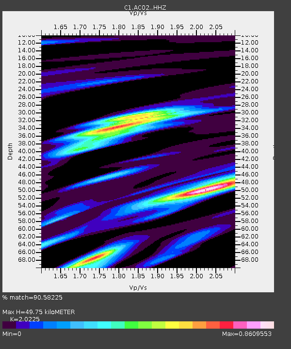
| Estimated Moho Depth: |
49.75 km |
| Estimated Crust Vp/Vs: |
2.02 |
| Assumed Crust Vp: |
6.514 km/s |
| Estimated Crust Vs: |
3.221 km/s |
| Estimated Crust Poisson's Ratio: |
0.34 |
|
| Radial Match: |
90.58225 % |
| Radial Bump: |
391 |
| Transverse Match: |
65.47753 % |
| Transverse Bump: |
400 |
| SOD ConfigId: |
13570011 |
| Insert Time: |
2019-05-02 21:26:09.091 +0000 |
| GWidth: |
2.5 |
| Max Bumps: |
400 |
| Tol: |
0.001 |
|

Signal To Noise
| Channel | StoN | STA | LTA |
| C1:AC02: :HHZ:20190405T16:21:27.918995Z | 22.375002 | 4.8435663E-6 | 2.1647222E-7 |
| C1:AC02: :HHN:20190405T16:21:27.918995Z | 6.395514 | 2.289225E-6 | 3.579423E-7 |
| C1:AC02: :HHE:20190405T16:21:27.918995Z | 5.2418528 | 1.6489735E-6 | 3.1457836E-7 |
| Arrivals |
| Ps | 8.3 SECOND |
| PpPs | 22 SECOND |
| PsPs/PpSs | 30 SECOND |


