You are here: Home > Network List > TA - USArray Transportable Network (new EarthScope stations) Stations List
> Station V18A Ganado, AZ, USA > Earthquake Result Viewer
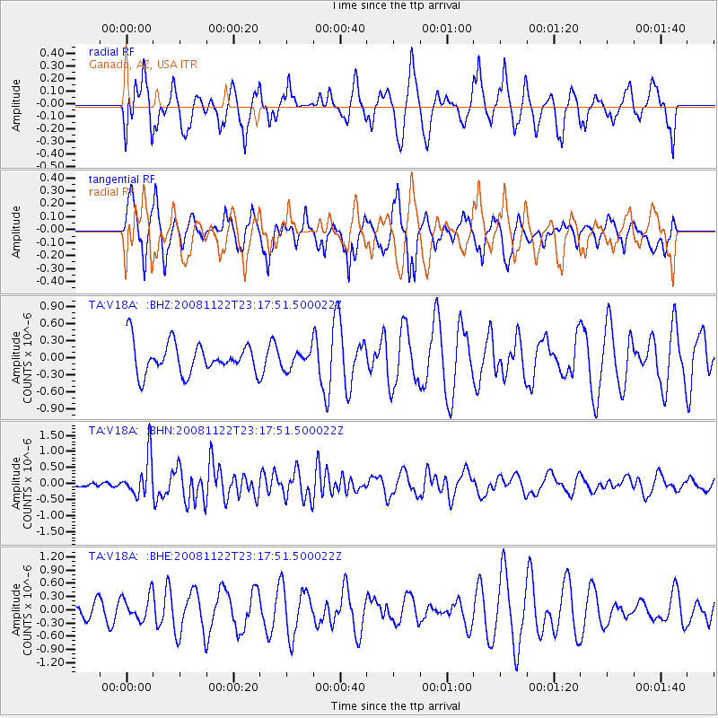
V18A Ganado, AZ, USA - Earthquake Result Viewer
*The percent match for this event was below the threshold and hence no stack was calculated.
| Earthquake location: |
Southeast Of Easter Island |
| Earthquake latitude/longitude: |
-37.2/-95.1 |
| Earthquake time(UTC): |
2008/11/22 (327) 23:06:47 GMT |
| Earthquake Depth: |
10 km |
| Earthquake Magnitude: |
5.6 MB, 5.3 MS, 5.7 MW, 5.7 MW |
| Earthquake Catalog/Contributor: |
WHDF/NEIC |
|
| Network: |
TA USArray Transportable Network (new EarthScope stations) |
| Station: |
V18A Ganado, AZ, USA |
| Lat/Lon: |
35.71 N/109.93 W |
| Elevation: |
1977 m |
|
| Distance: |
73.9 deg |
| Az: |
347.446 deg |
| Baz: |
167.694 deg |
| Ray Param: |
$rayparam |
*The percent match for this event was below the threshold and hence was not used in the summary stack. |
|
| Radial Match: |
56.112663 % |
| Radial Bump: |
379 |
| Transverse Match: |
79.14701 % |
| Transverse Bump: |
374 |
| SOD ConfigId: |
2658 |
| Insert Time: |
2010-03-06 21:21:27.324 +0000 |
| GWidth: |
2.5 |
| Max Bumps: |
400 |
| Tol: |
0.001 |
|
Signal To Noise
| Channel | StoN | STA | LTA |
| TA:V18A: :BHN:20081122T23:17:51.500022Z | 5.567329 | 6.1734903E-7 | 1.1088783E-7 |
| TA:V18A: :BHE:20081122T23:17:51.500022Z | 1.003395 | 2.9016394E-7 | 2.891822E-7 |
| TA:V18A: :BHZ:20081122T23:17:51.500022Z | 0.5723497 | 1.5433628E-7 | 2.696538E-7 |
| Arrivals |
| Ps | |
| PpPs | |
| PsPs/PpSs | |


