You are here: Home > Network List > GT - Global Telemetered Seismograph Network (USAF/USGS) Stations List
> Station LPAZ La Paz , Bolivia > Earthquake Result Viewer
LPAZ La Paz , Bolivia - Earthquake Result Viewer
| Earthquake location: |
South Sandwich Islands Region |
| Earthquake latitude/longitude: |
-55.9/-27.8 |
| Earthquake time(UTC): |
2019/04/05 (095) 16:14:16 GMT |
| Earthquake Depth: |
58 km |
| Earthquake Magnitude: |
6.5 mww |
| Earthquake Catalog/Contributor: |
NEIC PDE/us |
|
| Network: |
GT Global Telemetered Seismograph Network (USAF/USGS) |
| Station: |
LPAZ La Paz , Bolivia |
| Lat/Lon: |
16.17 S/68.08 W |
| Elevation: |
4817 m |
|
| Distance: |
50.1 deg |
| Az: |
305.982 deg |
| Baz: |
151.712 deg |
| Ray Param: |
0.06812924 |
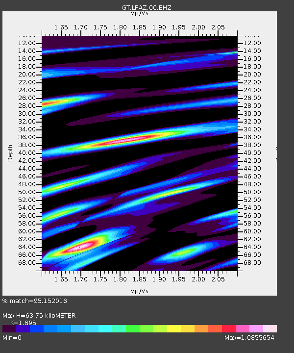
| Estimated Moho Depth: |
63.75 km |
| Estimated Crust Vp/Vs: |
1.70 |
| Assumed Crust Vp: |
6.454 km/s |
| Estimated Crust Vs: |
3.808 km/s |
| Estimated Crust Poisson's Ratio: |
0.23 |
|
| Radial Match: |
95.152016 % |
| Radial Bump: |
400 |
| Transverse Match: |
89.48721 % |
| Transverse Bump: |
400 |
| SOD ConfigId: |
13570011 |
| Insert Time: |
2019-05-02 21:26:56.322 +0000 |
| GWidth: |
2.5 |
| Max Bumps: |
400 |
| Tol: |
0.001 |
|
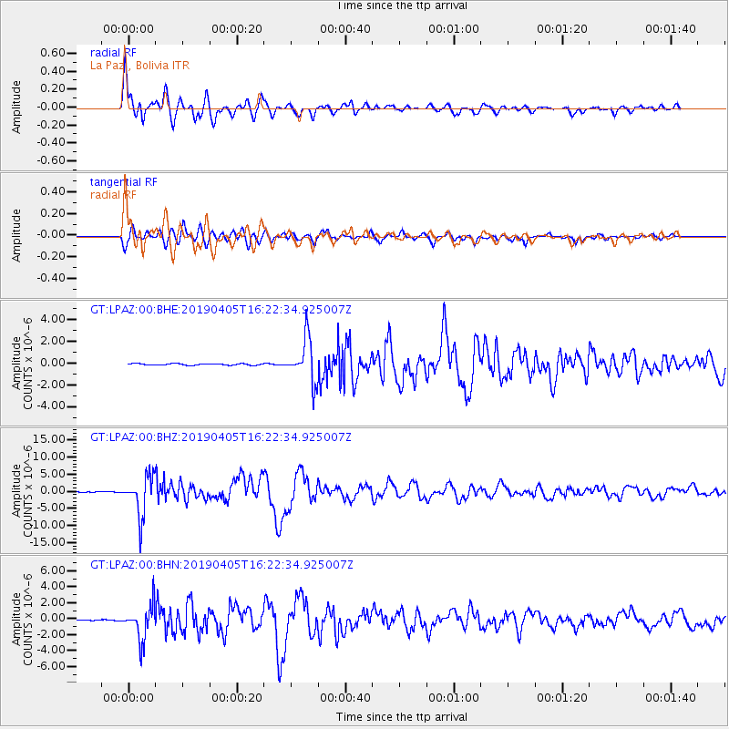
Signal To Noise
| Channel | StoN | STA | LTA |
| GT:LPAZ:00:BHZ:20190405T16:22:34.925007Z | 78.026634 | 5.949792E-6 | 7.625335E-8 |
| GT:LPAZ:00:BHN:20190405T16:22:34.925007Z | 19.872046 | 2.1817018E-6 | 1.0978748E-7 |
| GT:LPAZ:00:BHE:20190405T16:22:34.925007Z | 29.999125 | 2.0429047E-6 | 6.8098814E-8 |
| Arrivals |
| Ps | 7.3 SECOND |
| PpPs | 25 SECOND |
| PsPs/PpSs | 32 SECOND |


