You are here: Home > Network List > TS - TERRAscope (Southern California Seismic Network) Stations List
> Station DGR Domenigoni Valley Reservior, California, USA > Earthquake Result Viewer
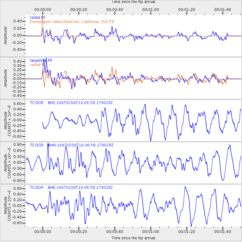
DGR Domenigoni Valley Reservior, California, USA - Earthquake Result Viewer
*The percent match for this event was below the threshold and hence no stack was calculated.
| Earthquake location: |
Near East Coast Of Kamchatka |
| Earthquake latitude/longitude: |
55.2/161.9 |
| Earthquake time(UTC): |
1997/02/09 (040) 18:57:37 GMT |
| Earthquake Depth: |
33 km |
| Earthquake Magnitude: |
5.9 MB, 5.3 MS, 5.8 UNKNOWN, 5.7 MW |
| Earthquake Catalog/Contributor: |
WHDF/NEIC |
|
| Network: |
TS TERRAscope (Southern California Seismic Network) |
| Station: |
DGR Domenigoni Valley Reservior, California, USA |
| Lat/Lon: |
33.65 N/117.01 W |
| Elevation: |
700 m |
|
| Distance: |
58.2 deg |
| Az: |
75.732 deg |
| Baz: |
318.279 deg |
| Ray Param: |
$rayparam |
*The percent match for this event was below the threshold and hence was not used in the summary stack. |
|
| Radial Match: |
62.022755 % |
| Radial Bump: |
400 |
| Transverse Match: |
71.29881 % |
| Transverse Bump: |
400 |
| SOD ConfigId: |
4480 |
| Insert Time: |
2010-02-26 14:10:10.263 +0000 |
| GWidth: |
2.5 |
| Max Bumps: |
400 |
| Tol: |
0.001 |
|
Signal To Noise
| Channel | StoN | STA | LTA |
| TS:DGR: :BHN:19970209T19:06:58.179028Z | 2.3543024 | 3.6844912E-7 | 1.5650033E-7 |
| TS:DGR: :BHE:19970209T19:06:58.179028Z | 1.5279775 | 1.9181695E-7 | 1.255365E-7 |
| TS:DGR: :BHZ:19970209T19:06:58.179028Z | 1.7856884 | 2.7124094E-7 | 1.5189713E-7 |
| Arrivals |
| Ps | |
| PpPs | |
| PsPs/PpSs | |


