You are here: Home > Network List > TA - USArray Transportable Network (new EarthScope stations) Stations List
> Station V18A Ganado, AZ, USA > Earthquake Result Viewer
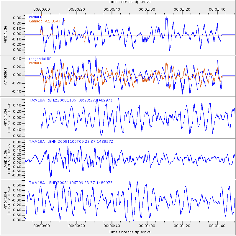
V18A Ganado, AZ, USA - Earthquake Result Viewer
*The percent match for this event was below the threshold and hence no stack was calculated.
| Earthquake location: |
Kermadec Islands, New Zealand |
| Earthquake latitude/longitude: |
-29.9/-177.4 |
| Earthquake time(UTC): |
2008/11/06 (311) 09:11:05 GMT |
| Earthquake Depth: |
19 km |
| Earthquake Magnitude: |
5.6 MB, 5.7 MS, 5.9 MW, 5.9 MW |
| Earthquake Catalog/Contributor: |
WHDF/NEIC |
|
| Network: |
TA USArray Transportable Network (new EarthScope stations) |
| Station: |
V18A Ganado, AZ, USA |
| Lat/Lon: |
35.71 N/109.93 W |
| Elevation: |
1977 m |
|
| Distance: |
91.0 deg |
| Az: |
48.767 deg |
| Baz: |
233.395 deg |
| Ray Param: |
$rayparam |
*The percent match for this event was below the threshold and hence was not used in the summary stack. |
|
| Radial Match: |
56.293495 % |
| Radial Bump: |
400 |
| Transverse Match: |
69.126816 % |
| Transverse Bump: |
400 |
| SOD ConfigId: |
2658 |
| Insert Time: |
2010-03-06 21:22:06.876 +0000 |
| GWidth: |
2.5 |
| Max Bumps: |
400 |
| Tol: |
0.001 |
|
Signal To Noise
| Channel | StoN | STA | LTA |
| TA:V18A: :BHN:20081106T09:23:37.148997Z | 2.2348013 | 2.7377703E-7 | 1.2250621E-7 |
| TA:V18A: :BHE:20081106T09:23:37.148997Z | 1.3887587 | 3.3882876E-7 | 2.4397957E-7 |
| TA:V18A: :BHZ:20081106T09:23:37.148997Z | 1.9917693 | 3.9903728E-7 | 2.0034312E-7 |
| Arrivals |
| Ps | |
| PpPs | |
| PsPs/PpSs | |


