You are here: Home > Network List > TA - USArray Transportable Network (new EarthScope stations) Stations List
> Station P16A Fountain Green, UT, USA > Earthquake Result Viewer
P16A Fountain Green, UT, USA - Earthquake Result Viewer
| Earthquake location: |
Southern Peru |
| Earthquake latitude/longitude: |
-16.0/-71.7 |
| Earthquake time(UTC): |
2008/07/08 (190) 09:13:07 GMT |
| Earthquake Depth: |
123 km |
| Earthquake Magnitude: |
5.8 MB, 6.2 MW, 6.2 MW |
| Earthquake Catalog/Contributor: |
WHDF/NEIC |
|
| Network: |
TA USArray Transportable Network (new EarthScope stations) |
| Station: |
P16A Fountain Green, UT, USA |
| Lat/Lon: |
39.61 N/111.66 W |
| Elevation: |
1822 m |
|
| Distance: |
66.7 deg |
| Az: |
327.33 deg |
| Baz: |
137.772 deg |
| Ray Param: |
0.057129886 |
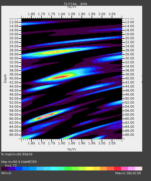
| Estimated Moho Depth: |
58.5 km |
| Estimated Crust Vp/Vs: |
1.72 |
| Assumed Crust Vp: |
6.207 km/s |
| Estimated Crust Vs: |
3.609 km/s |
| Estimated Crust Poisson's Ratio: |
0.24 |
|
| Radial Match: |
80.95638 % |
| Radial Bump: |
400 |
| Transverse Match: |
81.17102 % |
| Transverse Bump: |
400 |
| SOD ConfigId: |
2504 |
| Insert Time: |
2010-03-06 21:22:16.881 +0000 |
| GWidth: |
2.5 |
| Max Bumps: |
400 |
| Tol: |
0.001 |
|
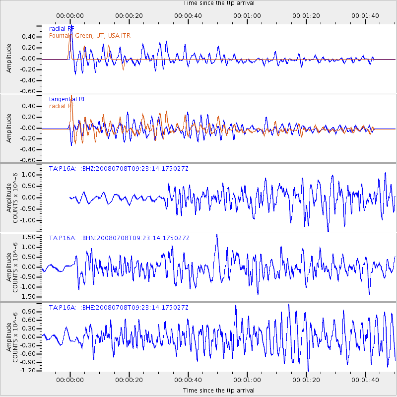
Signal To Noise
| Channel | StoN | STA | LTA |
| TA:P16A: :BHN:20080708T09:23:14.175027Z | 3.6041572 | 4.3750765E-7 | 1.2138972E-7 |
| TA:P16A: :BHE:20080708T09:23:14.175027Z | 1.7535272 | 1.5939439E-7 | 9.08993E-8 |
| TA:P16A: :BHZ:20080708T09:23:14.175027Z | 1.660784 | 2.1708334E-7 | 1.3071137E-7 |
| Arrivals |
| Ps | 7.1 SECOND |
| PpPs | 25 SECOND |
| PsPs/PpSs | 32 SECOND |


