P16A Fountain Green, UT, USA - Earthquake Result Viewer
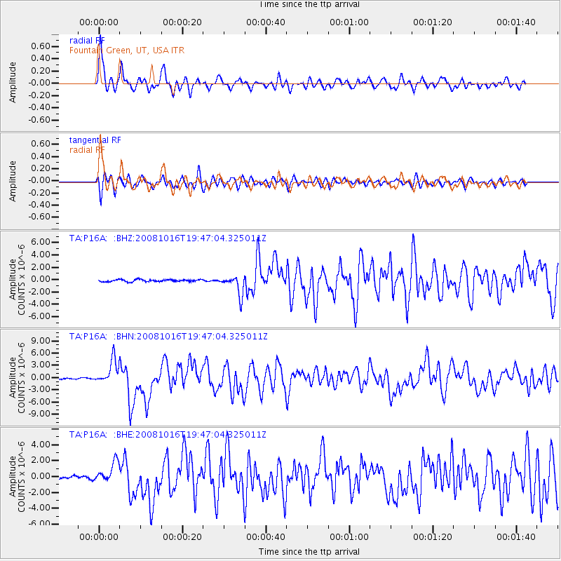
Earthquake location: Near Coast Of Chiapas, Mexico
Earthquake latitude/longitude: 14.4/-92.4
Earthquake time(UTC): 2008/10/16 (290) 19:41:25 GMT
Earthquake Depth: 24 km
Earthquake Magnitude: 6.1 MB, 6.6 MS, 6.7 MW, 6.6 MW
Earthquake Catalog/Contributor: WHDF/NEIC
Network: TA USArray Transportable Network (new EarthScope stations)
Station: P16A Fountain Green, UT, USA
Lat/Lon: 39.61 N/111.66 W
Elevation: 1822 m
Distance: 30.3 deg
Az: 329.582 deg
Baz: 140.579 deg
Ray Param: 0.07935637
Estimated Moho Depth: 54.0 km
Estimated Crust Vp/Vs: 1.60
Assumed Crust Vp: 6.207 km/s
Estimated Crust Vs: 3.879 km/s
Estimated Crust Poisson's Ratio: 0.18
Radial Match: 86.136055 %
Radial Bump: 400
Transverse Match: 74.089226 %
Transverse Bump: 400
SOD ConfigId: 2556
Insert Time: 2010-03-06 21:22:21.583 +0000
GWidth: 2.5
Max Bumps: 400
Tol: 0.001

Signal To Noise

ChannelStoNSTALTA
TA:P16A: :BHN:20081016T19:47:04.325011Z27.1409593.0494705E-61.1235677E-7
TA:P16A: :BHE:20081016T19:47:04.325011Z5.8425131.322078E-62.2628583E-7
TA:P16A: :BHZ:20081016T19:47:04.325011Z9.6836261.6179416E-61.6708015E-7
Arrivals
Ps5.7 SECOND
PpPs21 SECOND
PsPs/PpSs26 SECOND