You are here: Home > Network List > TA - USArray Transportable Network (new EarthScope stations) Stations List
> Station P16A Fountain Green, UT, USA > Earthquake Result Viewer
P16A Fountain Green, UT, USA - Earthquake Result Viewer
| Earthquake location: |
Kermadec Islands Region |
| Earthquake latitude/longitude: |
-27.4/-176.3 |
| Earthquake time(UTC): |
2009/02/18 (049) 21:53:45 GMT |
| Earthquake Depth: |
25 km |
| Earthquake Magnitude: |
6.8 MB, 7.2 MS, 6.9 MW, 6.9 MW |
| Earthquake Catalog/Contributor: |
WHDF/NEIC |
|
| Network: |
TA USArray Transportable Network (new EarthScope stations) |
| Station: |
P16A Fountain Green, UT, USA |
| Lat/Lon: |
39.61 N/111.66 W |
| Elevation: |
1822 m |
|
| Distance: |
89.8 deg |
| Az: |
44.286 deg |
| Baz: |
233.459 deg |
| Ray Param: |
0.04171376 |
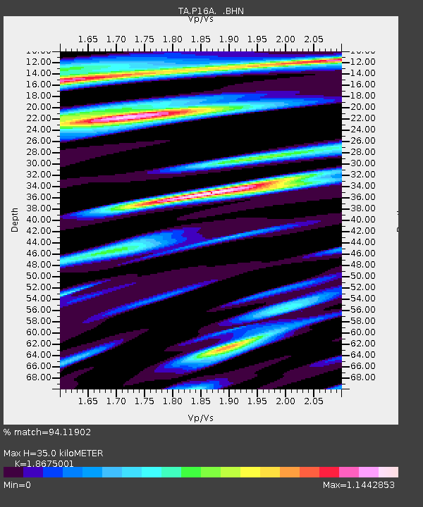
| Estimated Moho Depth: |
35.0 km |
| Estimated Crust Vp/Vs: |
1.87 |
| Assumed Crust Vp: |
6.207 km/s |
| Estimated Crust Vs: |
3.324 km/s |
| Estimated Crust Poisson's Ratio: |
0.30 |
|
| Radial Match: |
94.11902 % |
| Radial Bump: |
400 |
| Transverse Match: |
92.61523 % |
| Transverse Bump: |
400 |
| SOD ConfigId: |
2658 |
| Insert Time: |
2010-03-06 21:22:28.178 +0000 |
| GWidth: |
2.5 |
| Max Bumps: |
400 |
| Tol: |
0.001 |
|

Signal To Noise
| Channel | StoN | STA | LTA |
| TA:P16A: :BHN:20090218T22:06:10.199001Z | 12.699669 | 2.1332344E-6 | 1.679756E-7 |
| TA:P16A: :BHE:20090218T22:06:10.199001Z | 1.101852 | 3.1252054E-7 | 2.8363203E-7 |
| TA:P16A: :BHZ:20090218T22:06:10.199001Z | 2.004123 | 4.252562E-7 | 2.1219066E-7 |
| Arrivals |
| Ps | 5.0 SECOND |
| PpPs | 16 SECOND |
| PsPs/PpSs | 21 SECOND |


