You are here: Home > Network List > TA - USArray Transportable Network (new EarthScope stations) Stations List
> Station P16A Fountain Green, UT, USA > Earthquake Result Viewer
P16A Fountain Green, UT, USA - Earthquake Result Viewer
| Earthquake location: |
Near West Coast Of Colombia |
| Earthquake latitude/longitude: |
3.0/-78.0 |
| Earthquake time(UTC): |
2007/09/10 (253) 01:49:14 GMT |
| Earthquake Depth: |
31 km |
| Earthquake Magnitude: |
6.1 MB, 6.7 MS, 6.8 MW |
| Earthquake Catalog/Contributor: |
WHDF/NEIC |
|
| Network: |
TA USArray Transportable Network (new EarthScope stations) |
| Station: |
P16A Fountain Green, UT, USA |
| Lat/Lon: |
39.61 N/111.66 W |
| Elevation: |
1822 m |
|
| Distance: |
47.6 deg |
| Az: |
324.507 deg |
| Baz: |
131.359 deg |
| Ray Param: |
0.069847725 |
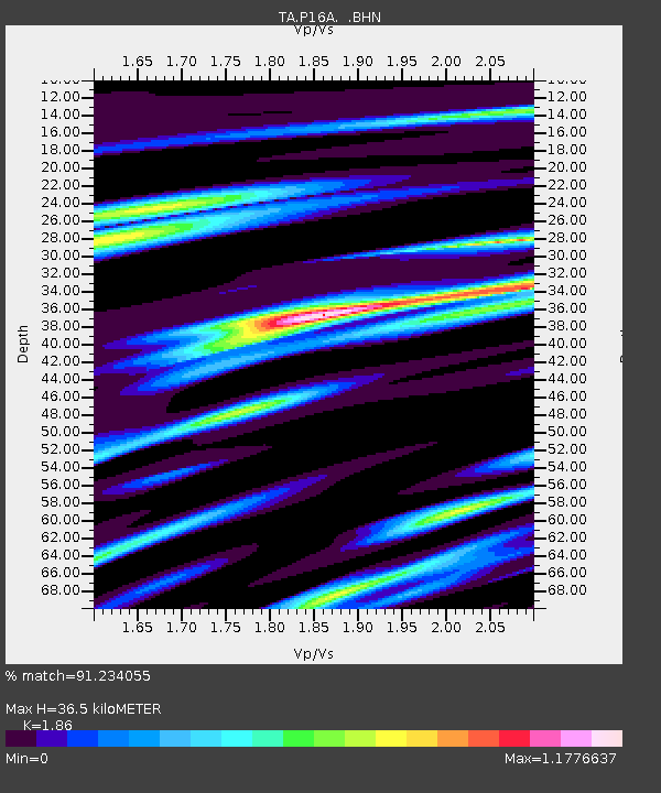
| Estimated Moho Depth: |
36.5 km |
| Estimated Crust Vp/Vs: |
1.86 |
| Assumed Crust Vp: |
6.207 km/s |
| Estimated Crust Vs: |
3.337 km/s |
| Estimated Crust Poisson's Ratio: |
0.30 |
|
| Radial Match: |
91.234055 % |
| Radial Bump: |
400 |
| Transverse Match: |
73.94594 % |
| Transverse Bump: |
400 |
| SOD ConfigId: |
2564 |
| Insert Time: |
2010-03-06 21:22:35.425 +0000 |
| GWidth: |
2.5 |
| Max Bumps: |
400 |
| Tol: |
0.001 |
|
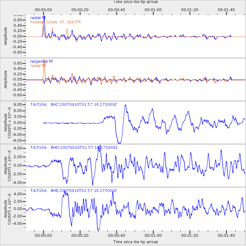
Signal To Noise
| Channel | StoN | STA | LTA |
| TA:P16A: :BHN:20070910T01:57:16.273009Z | 2.8793144 | 4.5664945E-7 | 1.5859659E-7 |
| TA:P16A: :BHE:20070910T01:57:16.273009Z | 3.4594543 | 5.666908E-7 | 1.638093E-7 |
| TA:P16A: :BHZ:20070910T01:57:16.273009Z | 14.764603 | 1.551797E-6 | 1.0510252E-7 |
| Arrivals |
| Ps | 5.3 SECOND |
| PpPs | 16 SECOND |
| PsPs/PpSs | 21 SECOND |


