You are here: Home > Network List > MM - Myanmar National Seismic Network Stations List
> Station TGI Taung Gyi, Myanmar > Earthquake Result Viewer
TGI Taung Gyi, Myanmar - Earthquake Result Viewer
| Earthquake location: |
Banda Sea |
| Earthquake latitude/longitude: |
-6.8/125.0 |
| Earthquake time(UTC): |
2019/04/06 (096) 21:55:01 GMT |
| Earthquake Depth: |
539 km |
| Earthquake Magnitude: |
6.3 Mww |
| Earthquake Catalog/Contributor: |
NEIC PDE/us |
|
| Network: |
MM Myanmar National Seismic Network |
| Station: |
TGI Taung Gyi, Myanmar |
| Lat/Lon: |
20.77 N/97.03 E |
| Elevation: |
1458 m |
|
| Distance: |
38.8 deg |
| Az: |
315.575 deg |
| Baz: |
132.035 deg |
| Ray Param: |
0.07265687 |
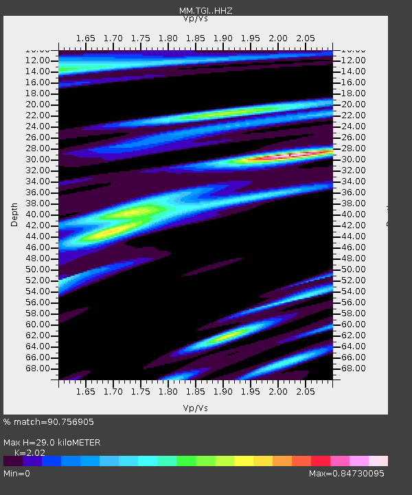
| Estimated Moho Depth: |
29.0 km |
| Estimated Crust Vp/Vs: |
2.02 |
| Assumed Crust Vp: |
6.316 km/s |
| Estimated Crust Vs: |
3.127 km/s |
| Estimated Crust Poisson's Ratio: |
0.34 |
|
| Radial Match: |
90.756905 % |
| Radial Bump: |
334 |
| Transverse Match: |
72.511185 % |
| Transverse Bump: |
400 |
| SOD ConfigId: |
13570011 |
| Insert Time: |
2019-05-02 21:37:51.598 +0000 |
| GWidth: |
2.5 |
| Max Bumps: |
400 |
| Tol: |
0.001 |
|

Signal To Noise
| Channel | StoN | STA | LTA |
| MM:TGI: :HHZ:20190406T22:01:09.970008Z | 50.550148 | 2.8852587E-6 | 5.7077155E-8 |
| MM:TGI: :HHN:20190406T22:01:09.970008Z | 25.212364 | 1.1527457E-6 | 4.5721443E-8 |
| MM:TGI: :HHE:20190406T22:01:09.970008Z | 17.961056 | 1.0806904E-6 | 6.016853E-8 |
| Arrivals |
| Ps | 5.0 SECOND |
| PpPs | 13 SECOND |
| PsPs/PpSs | 18 SECOND |


