You are here: Home > Network List > TS - TERRAscope (Southern California Seismic Network) Stations List
> Station DGR Domenigoni Valley Reservior, California, USA > Earthquake Result Viewer
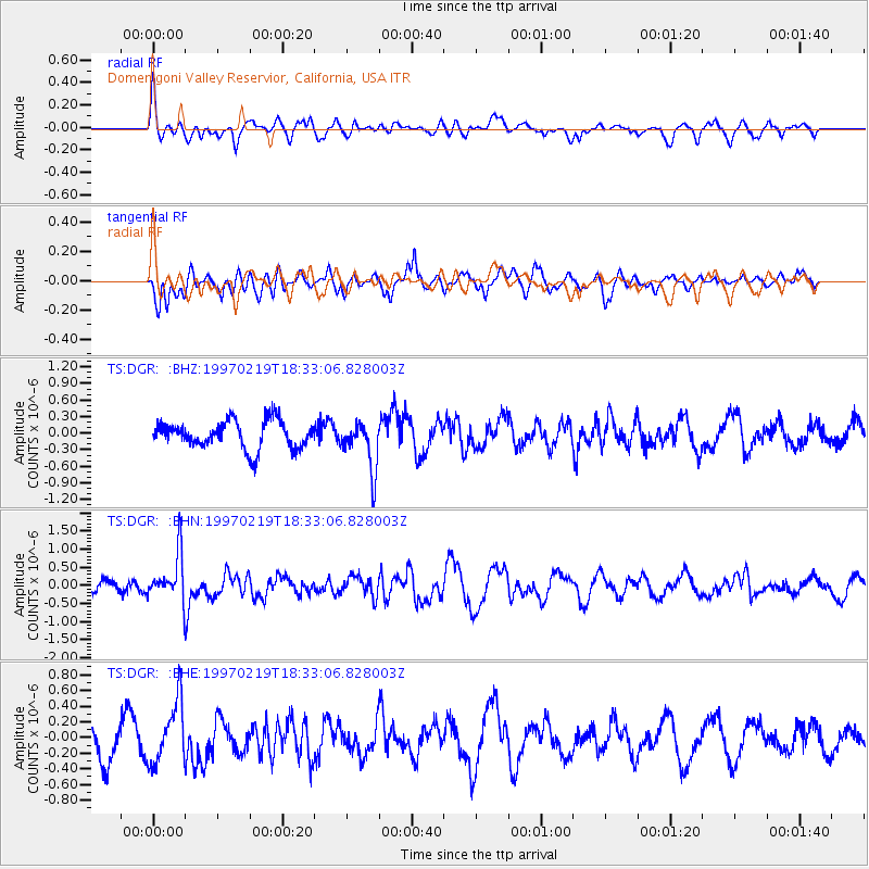
DGR Domenigoni Valley Reservior, California, USA - Earthquake Result Viewer
*The percent match for this event was below the threshold and hence no stack was calculated.
| Earthquake location: |
Colombia |
| Earthquake latitude/longitude: |
4.6/-76.5 |
| Earthquake time(UTC): |
1997/02/19 (050) 18:25:12 GMT |
| Earthquake Depth: |
101 km |
| Earthquake Magnitude: |
5.5 MB, 5.8 UNKNOWN, 5.7 MW |
| Earthquake Catalog/Contributor: |
WHDF/NEIC |
|
| Network: |
TS TERRAscope (Southern California Seismic Network) |
| Station: |
DGR Domenigoni Valley Reservior, California, USA |
| Lat/Lon: |
33.65 N/117.01 W |
| Elevation: |
700 m |
|
| Distance: |
47.5 deg |
| Az: |
312.679 deg |
| Baz: |
118.529 deg |
| Ray Param: |
$rayparam |
*The percent match for this event was below the threshold and hence was not used in the summary stack. |
|
| Radial Match: |
53.74355 % |
| Radial Bump: |
396 |
| Transverse Match: |
51.25144 % |
| Transverse Bump: |
400 |
| SOD ConfigId: |
4480 |
| Insert Time: |
2010-02-26 14:10:12.178 +0000 |
| GWidth: |
2.5 |
| Max Bumps: |
400 |
| Tol: |
0.001 |
|
Signal To Noise
| Channel | StoN | STA | LTA |
| TS:DGR: :BHN:19970219T18:33:06.828003Z | 3.4537435 | 6.4998204E-7 | 1.881964E-7 |
| TS:DGR: :BHE:19970219T18:33:06.828003Z | 1.6825618 | 3.9372614E-7 | 2.3400399E-7 |
| TS:DGR: :BHZ:19970219T18:33:06.828003Z | 1.7866087 | 4.4896925E-7 | 2.512969E-7 |
| Arrivals |
| Ps | |
| PpPs | |
| PsPs/PpSs | |


