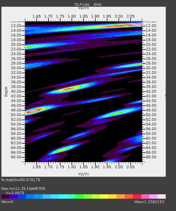
P16A Fountain Green, UT, USA - Earthquake Result Viewer
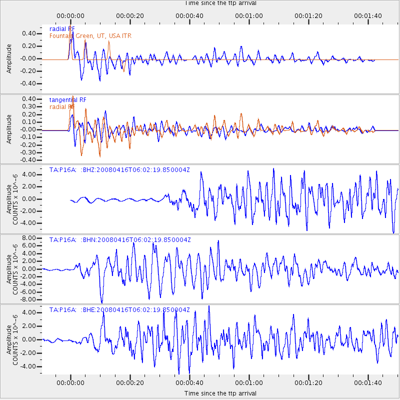
Earthquake location: Andreanof Islands, Aleutian Is.
Earthquake latitude/longitude: 51.9/-179.2
Earthquake time(UTC): 2008/04/16 (107) 05:54:19 GMT
Earthquake Depth: 13 km
Earthquake Magnitude: 6.1 MB, 6.5 MS, 6.6 MW, 6.6 MW
Earthquake Catalog/Contributor: WHDF/NEIC
Network: TA USArray Transportable Network (new EarthScope stations)
Station: P16A Fountain Green, UT, USA
Lat/Lon: 39.61 N/111.66 W
Elevation: 1822 m
Distance: 47.0 deg
Az: 77.233 deg
Baz: 308.499 deg
Ray Param: 0.07024709
Estimated Moho Depth: 11.25 km
Estimated Crust Vp/Vs: 2.10
Assumed Crust Vp: 6.207 km/s
Estimated Crust Vs: 2.959 km/s
Estimated Crust Poisson's Ratio: 0.35
Radial Match: 90.570175 %
Radial Bump: 400
Transverse Match: 82.6539 %
Transverse Bump: 400
SOD ConfigId: 2504
Insert Time: 2010-03-06 21:22:48.353 +0000
GWidth: 2.5
Max Bumps: 400
Tol: 0.001

Signal To Noise

ChannelStoNSTALTA
TA:P16A: :BHN:20080416T06:02:19.850004Z4.93280031.0091775E-62.045851E-7
TA:P16A: :BHE:20080416T06:02:19.850004Z1.0144332.6273304E-72.5899496E-7
TA:P16A: :BHZ:20080416T06:02:19.850004Z2.04998974.5173056E-72.2035748E-7
Arrivals
Ps2.1 SECOND
PpPs5.3 SECOND
PsPs/PpSs7.4 SECOND