You are here: Home > Network List > TA - USArray Transportable Network (new EarthScope stations) Stations List
> Station P16A Fountain Green, UT, USA > Earthquake Result Viewer
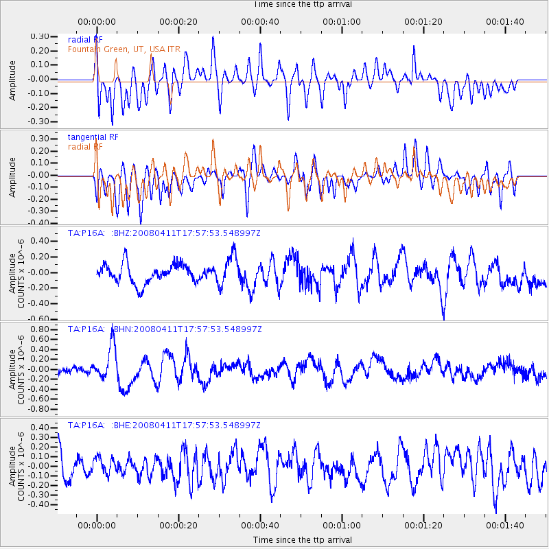
P16A Fountain Green, UT, USA - Earthquake Result Viewer
*The percent match for this event was below the threshold and hence no stack was calculated.
| Earthquake location: |
Loyalty Islands |
| Earthquake latitude/longitude: |
-20.4/168.8 |
| Earthquake time(UTC): |
2008/04/11 (102) 17:45:05 GMT |
| Earthquake Depth: |
35 km |
| Earthquake Magnitude: |
5.7 MB, 5.9 MS, 6.0 MW, 6.0 MW |
| Earthquake Catalog/Contributor: |
WHDF/NEIC |
|
| Network: |
TA USArray Transportable Network (new EarthScope stations) |
| Station: |
P16A Fountain Green, UT, USA |
| Lat/Lon: |
39.61 N/111.66 W |
| Elevation: |
1822 m |
|
| Distance: |
95.1 deg |
| Az: |
49.695 deg |
| Baz: |
247.819 deg |
| Ray Param: |
$rayparam |
*The percent match for this event was below the threshold and hence was not used in the summary stack. |
|
| Radial Match: |
61.482193 % |
| Radial Bump: |
400 |
| Transverse Match: |
70.02165 % |
| Transverse Bump: |
400 |
| SOD ConfigId: |
2504 |
| Insert Time: |
2010-03-06 21:22:54.387 +0000 |
| GWidth: |
2.5 |
| Max Bumps: |
400 |
| Tol: |
0.001 |
|
Signal To Noise
| Channel | StoN | STA | LTA |
| TA:P16A: :BHN:20080411T17:57:53.548997Z | 4.060391 | 3.524892E-7 | 8.681163E-8 |
| TA:P16A: :BHE:20080411T17:57:53.548997Z | 0.78365 | 9.024127E-8 | 1.15155075E-7 |
| TA:P16A: :BHZ:20080411T17:57:53.548997Z | 1.5725458 | 1.9477143E-7 | 1.2385739E-7 |
| Arrivals |
| Ps | |
| PpPs | |
| PsPs/PpSs | |


