You are here: Home > Network List > TM - Thai Seismic Monitoring Network Stations List
> Station NAYO NAYO staion > Earthquake Result Viewer
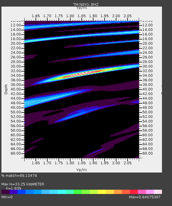
NAYO NAYO staion - Earthquake Result Viewer
| Earthquake location: |
Banda Sea |
| Earthquake latitude/longitude: |
-6.8/125.0 |
| Earthquake time(UTC): |
2019/04/06 (096) 21:55:01 GMT |
| Earthquake Depth: |
539 km |
| Earthquake Magnitude: |
6.3 Mww |
| Earthquake Catalog/Contributor: |
NEIC PDE/us |
|
| Network: |
TM Thai Seismic Monitoring Network |
| Station: |
NAYO NAYO staion |
| Lat/Lon: |
14.32 N/101.32 E |
| Elevation: |
106 m |
|
| Distance: |
31.5 deg |
| Az: |
311.87 deg |
| Baz: |
130.288 deg |
| Ray Param: |
0.07666238 |
| Estimated Moho Depth: |
33.25 km |
| Estimated Crust Vp/Vs: |
1.84 |
| Assumed Crust Vp: |
6.498 km/s |
| Estimated Crust Vs: |
3.541 km/s |
| Estimated Crust Poisson's Ratio: |
0.29 |
|
| Radial Match: |
88.10476 % |
| Radial Bump: |
312 |
| Transverse Match: |
70.8624 % |
| Transverse Bump: |
400 |
| SOD ConfigId: |
13570011 |
| Insert Time: |
2019-05-02 21:39:16.849 +0000 |
| GWidth: |
2.5 |
| Max Bumps: |
400 |
| Tol: |
0.001 |
|

Signal To Noise
| Channel | StoN | STA | LTA |
| TM:NAYO: :BHZ:20190406T22:00:09.340003Z | 11.545242 | 1.793691E-5 | 1.5536192E-6 |
| TM:NAYO: :BHN:20190406T22:00:09.340003Z | 6.1805186 | 6.946066E-6 | 1.1238646E-6 |
| TM:NAYO: :BHE:20190406T22:00:09.340003Z | 8.667878 | 7.6163305E-6 | 8.786846E-7 |
| Arrivals |
| Ps | 4.6 SECOND |
| PpPs | 13 SECOND |
| PsPs/PpSs | 18 SECOND |


