You are here: Home > Network List > TA - USArray Transportable Network (new EarthScope stations) Stations List
> Station P16A Fountain Green, UT, USA > Earthquake Result Viewer
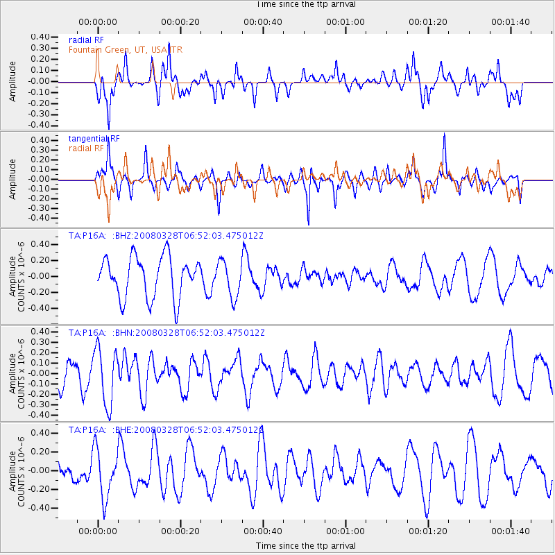
P16A Fountain Green, UT, USA - Earthquake Result Viewer
*The percent match for this event was below the threshold and hence no stack was calculated.
| Earthquake location: |
South Of Kermadec Islands |
| Earthquake latitude/longitude: |
-32.9/179.4 |
| Earthquake time(UTC): |
2008/03/28 (088) 06:39:47 GMT |
| Earthquake Depth: |
365 km |
| Earthquake Magnitude: |
5.6 MW, 5.3 MB, 5.5 MW |
| Earthquake Catalog/Contributor: |
WHDF/NEIC |
|
| Network: |
TA USArray Transportable Network (new EarthScope stations) |
| Station: |
P16A Fountain Green, UT, USA |
| Lat/Lon: |
39.61 N/111.66 W |
| Elevation: |
1822 m |
|
| Distance: |
96.3 deg |
| Az: |
46.51 deg |
| Baz: |
232.208 deg |
| Ray Param: |
$rayparam |
*The percent match for this event was below the threshold and hence was not used in the summary stack. |
|
| Radial Match: |
72.7186 % |
| Radial Bump: |
400 |
| Transverse Match: |
52.965424 % |
| Transverse Bump: |
331 |
| SOD ConfigId: |
2504 |
| Insert Time: |
2010-03-06 21:23:38.390 +0000 |
| GWidth: |
2.5 |
| Max Bumps: |
400 |
| Tol: |
0.001 |
|
Signal To Noise
| Channel | StoN | STA | LTA |
| TA:P16A: :BHN:20080328T06:52:03.475012Z | 2.2152846 | 2.7879008E-7 | 1.2584843E-7 |
| TA:P16A: :BHE:20080328T06:52:03.475012Z | 2.1135135 | 2.6412704E-7 | 1.249706E-7 |
| TA:P16A: :BHZ:20080328T06:52:03.475012Z | 0.9216156 | 2.347313E-7 | 2.5469546E-7 |
| Arrivals |
| Ps | |
| PpPs | |
| PsPs/PpSs | |


