You are here: Home > Network List > TA - USArray Transportable Network (new EarthScope stations) Stations List
> Station P16A Fountain Green, UT, USA > Earthquake Result Viewer
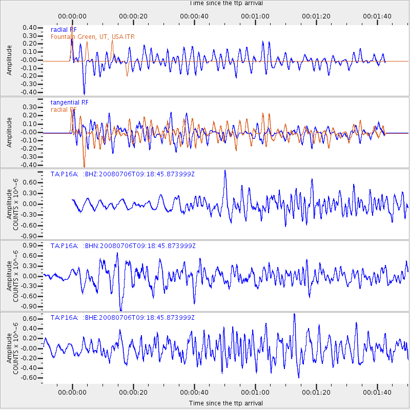
P16A Fountain Green, UT, USA - Earthquake Result Viewer
*The percent match for this event was below the threshold and hence no stack was calculated.
| Earthquake location: |
Kuril Islands |
| Earthquake latitude/longitude: |
45.4/151.0 |
| Earthquake time(UTC): |
2008/07/06 (188) 09:08:20 GMT |
| Earthquake Depth: |
10 km |
| Earthquake Magnitude: |
5.8 MB, 5.4 MS, 5.7 MW, 5.7 MW |
| Earthquake Catalog/Contributor: |
WHDF/NEIC |
|
| Network: |
TA USArray Transportable Network (new EarthScope stations) |
| Station: |
P16A Fountain Green, UT, USA |
| Lat/Lon: |
39.61 N/111.66 W |
| Elevation: |
1822 m |
|
| Distance: |
67.6 deg |
| Az: |
55.94 deg |
| Baz: |
310.911 deg |
| Ray Param: |
$rayparam |
*The percent match for this event was below the threshold and hence was not used in the summary stack. |
|
| Radial Match: |
63.420982 % |
| Radial Bump: |
400 |
| Transverse Match: |
70.33237 % |
| Transverse Bump: |
400 |
| SOD ConfigId: |
2504 |
| Insert Time: |
2010-03-06 21:24:03.996 +0000 |
| GWidth: |
2.5 |
| Max Bumps: |
400 |
| Tol: |
0.001 |
|
Signal To Noise
| Channel | StoN | STA | LTA |
| TA:P16A: :BHN:20080706T09:18:45.873999Z | 2.4900413 | 2.2191645E-7 | 8.91216E-8 |
| TA:P16A: :BHE:20080706T09:18:45.873999Z | 0.9252217 | 1.0673772E-7 | 1.15364486E-7 |
| TA:P16A: :BHZ:20080706T09:18:45.873999Z | 1.8813196 | 1.7119827E-7 | 9.099903E-8 |
| Arrivals |
| Ps | |
| PpPs | |
| PsPs/PpSs | |


