You are here: Home > Network List > TA - USArray Transportable Network (new EarthScope stations) Stations List
> Station P16A Fountain Green, UT, USA > Earthquake Result Viewer
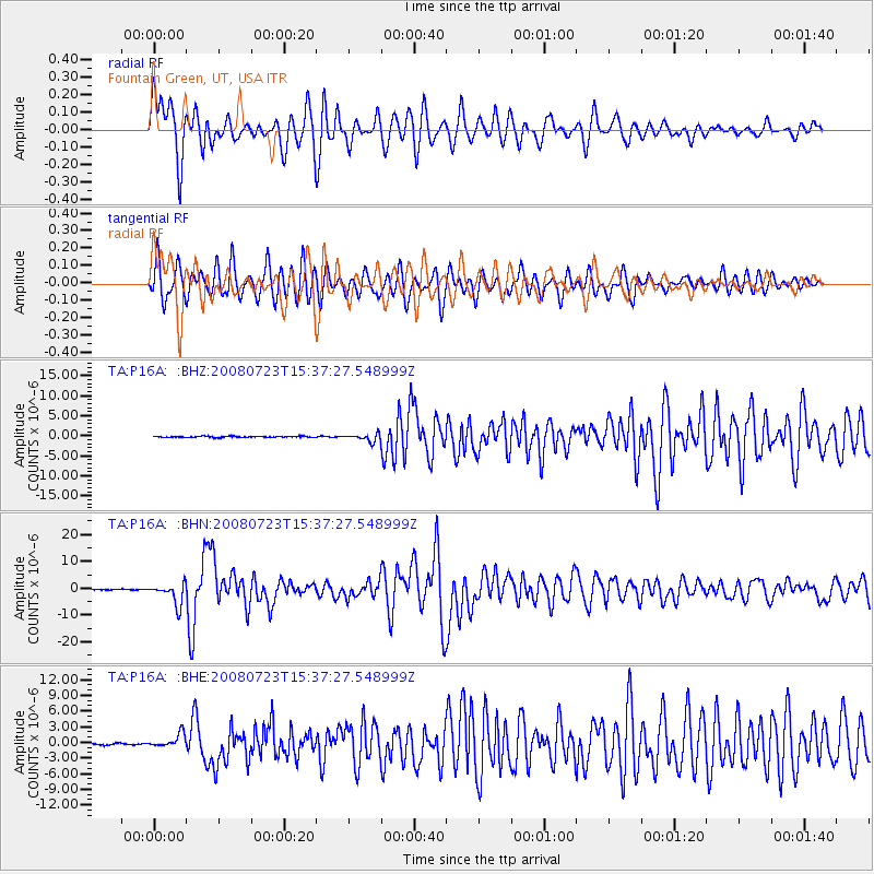
P16A Fountain Green, UT, USA - Earthquake Result Viewer
*The percent match for this event was below the threshold and hence no stack was calculated.
| Earthquake location: |
Eastern Honshu, Japan |
| Earthquake latitude/longitude: |
39.8/141.5 |
| Earthquake time(UTC): |
2008/07/23 (205) 15:26:19 GMT |
| Earthquake Depth: |
108 km |
| Earthquake Magnitude: |
6.6 MB, 6.8 MW, 6.8 MW |
| Earthquake Catalog/Contributor: |
WHDF/NEIC |
|
| Network: |
TA USArray Transportable Network (new EarthScope stations) |
| Station: |
P16A Fountain Green, UT, USA |
| Lat/Lon: |
39.61 N/111.66 W |
| Elevation: |
1822 m |
|
| Distance: |
76.6 deg |
| Az: |
49.464 deg |
| Baz: |
310.721 deg |
| Ray Param: |
$rayparam |
*The percent match for this event was below the threshold and hence was not used in the summary stack. |
|
| Radial Match: |
88.157814 % |
| Radial Bump: |
400 |
| Transverse Match: |
88.92966 % |
| Transverse Bump: |
400 |
| SOD ConfigId: |
2504 |
| Insert Time: |
2010-03-06 21:24:14.284 +0000 |
| GWidth: |
2.5 |
| Max Bumps: |
400 |
| Tol: |
0.001 |
|
Signal To Noise
| Channel | StoN | STA | LTA |
| TA:P16A: :BHN:20080723T15:37:27.548999Z | 25.16074 | 3.962022E-6 | 1.5746842E-7 |
| TA:P16A: :BHE:20080723T15:37:27.548999Z | 6.194871 | 1.2885351E-6 | 2.0800033E-7 |
| TA:P16A: :BHZ:20080723T15:37:27.548999Z | 6.545001 | 9.268724E-7 | 1.4161533E-7 |
| Arrivals |
| Ps | |
| PpPs | |
| PsPs/PpSs | |


