You are here: Home > Network List > TA - USArray Transportable Network (new EarthScope stations) Stations List
> Station P16A Fountain Green, UT, USA > Earthquake Result Viewer
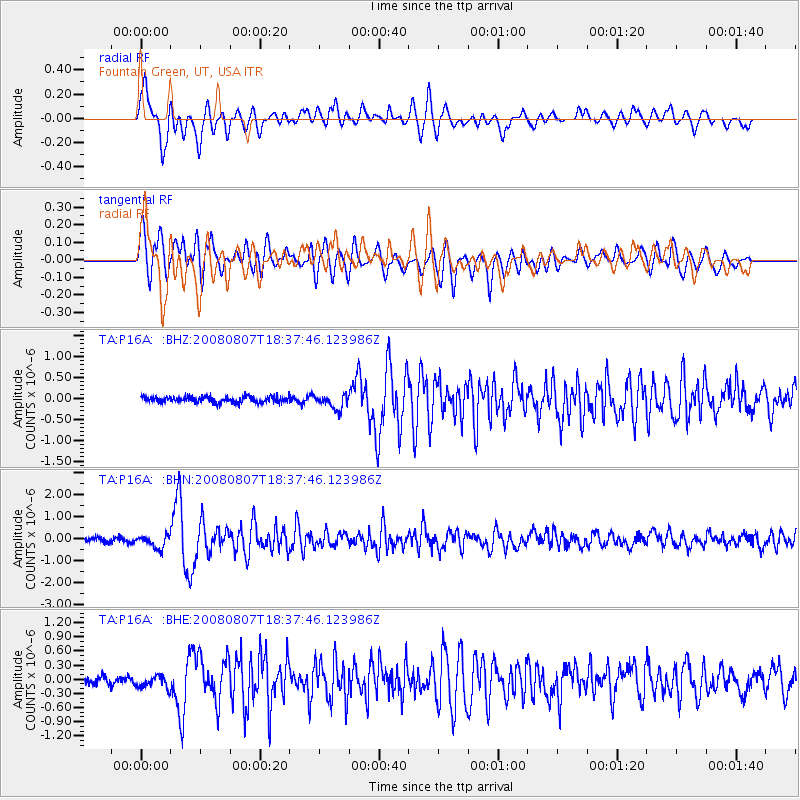
P16A Fountain Green, UT, USA - Earthquake Result Viewer
*The percent match for this event was below the threshold and hence no stack was calculated.
| Earthquake location: |
Andreanof Islands, Aleutian Is. |
| Earthquake latitude/longitude: |
52.2/-175.7 |
| Earthquake time(UTC): |
2008/08/07 (220) 18:30:03 GMT |
| Earthquake Depth: |
12 km |
| Earthquake Magnitude: |
5.6 MB, 5.5 MS, 5.8 MW, 5.8 MW |
| Earthquake Catalog/Contributor: |
WHDF/NEIC |
|
| Network: |
TA USArray Transportable Network (new EarthScope stations) |
| Station: |
P16A Fountain Green, UT, USA |
| Lat/Lon: |
39.61 N/111.66 W |
| Elevation: |
1822 m |
|
| Distance: |
44.9 deg |
| Az: |
79.876 deg |
| Baz: |
308.326 deg |
| Ray Param: |
$rayparam |
*The percent match for this event was below the threshold and hence was not used in the summary stack. |
|
| Radial Match: |
80.75017 % |
| Radial Bump: |
400 |
| Transverse Match: |
70.858536 % |
| Transverse Bump: |
400 |
| SOD ConfigId: |
2504 |
| Insert Time: |
2010-03-06 21:24:17.966 +0000 |
| GWidth: |
2.5 |
| Max Bumps: |
400 |
| Tol: |
0.001 |
|
Signal To Noise
| Channel | StoN | STA | LTA |
| TA:P16A: :BHN:20080807T18:37:46.123986Z | 3.0887685 | 2.9992057E-7 | 9.7100376E-8 |
| TA:P16A: :BHE:20080807T18:37:46.123986Z | 1.2778378 | 1.311431E-7 | 1.0262891E-7 |
| TA:P16A: :BHZ:20080807T18:37:46.123986Z | 2.2914872 | 1.6583773E-7 | 7.237122E-8 |
| Arrivals |
| Ps | |
| PpPs | |
| PsPs/PpSs | |


