You are here: Home > Network List > IU - Global Seismograph Network (GSN - IRIS/USGS) Stations List
> Station CTAO Charters Towers, Australia > Earthquake Result Viewer
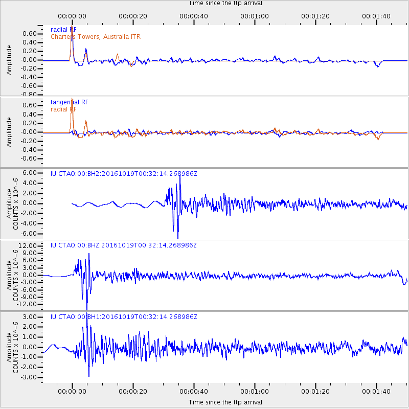
CTAO Charters Towers, Australia - Earthquake Result Viewer
*The percent match for this event was below the threshold and hence no stack was calculated.
| Earthquake location: |
Java Sea |
| Earthquake latitude/longitude: |
-4.9/108.2 |
| Earthquake time(UTC): |
2016/10/19 (293) 00:26:01 GMT |
| Earthquake Depth: |
614 km |
| Earthquake Magnitude: |
6.6 MWW, 6.6 MWC, 6.7 MWB |
| Earthquake Catalog/Contributor: |
NEIC PDE/NEIC COMCAT |
|
| Network: |
IU Global Seismograph Network (GSN - IRIS/USGS) |
| Station: |
CTAO Charters Towers, Australia |
| Lat/Lon: |
20.09 S/146.25 E |
| Elevation: |
357 m |
|
| Distance: |
40.0 deg |
| Az: |
115.61 deg |
| Baz: |
287.058 deg |
| Ray Param: |
$rayparam |
*The percent match for this event was below the threshold and hence was not used in the summary stack. |
|
| Radial Match: |
79.33706 % |
| Radial Bump: |
353 |
| Transverse Match: |
63.553688 % |
| Transverse Bump: |
400 |
| SOD ConfigId: |
1815711 |
| Insert Time: |
2016-11-02 00:27:13.075 +0000 |
| GWidth: |
2.5 |
| Max Bumps: |
400 |
| Tol: |
0.001 |
|
Signal To Noise
| Channel | StoN | STA | LTA |
| IU:CTAO:00:BHZ:20161019T00:32:14.268986Z | 13.529818 | 4.32995E-6 | 3.2003018E-7 |
| IU:CTAO:00:BH1:20161019T00:32:14.268986Z | 4.2294583 | 1.0268441E-6 | 2.4278384E-7 |
| IU:CTAO:00:BH2:20161019T00:32:14.268986Z | 7.3193326 | 2.2324161E-6 | 3.050027E-7 |
| Arrivals |
| Ps | |
| PpPs | |
| PsPs/PpSs | |


