You are here: Home > Network List > TA - USArray Transportable Network (new EarthScope stations) Stations List
> Station D20A Manuel Ranch, Winnett, MT, USA > Earthquake Result Viewer
D20A Manuel Ranch, Winnett, MT, USA - Earthquake Result Viewer
| Earthquake location: |
Hokkaido, Japan Region |
| Earthquake latitude/longitude: |
41.9/143.8 |
| Earthquake time(UTC): |
2008/09/11 (255) 00:20:50 GMT |
| Earthquake Depth: |
25 km |
| Earthquake Magnitude: |
6.1 MB, 7.0 MS, 6.8 MW, 6.8 MW |
| Earthquake Catalog/Contributor: |
WHDF/NEIC |
|
| Network: |
TA USArray Transportable Network (new EarthScope stations) |
| Station: |
D20A Manuel Ranch, Winnett, MT, USA |
| Lat/Lon: |
47.09 N/108.14 W |
| Elevation: |
902 m |
|
| Distance: |
70.9 deg |
| Az: |
43.413 deg |
| Baz: |
311.326 deg |
| Ray Param: |
0.05464243 |
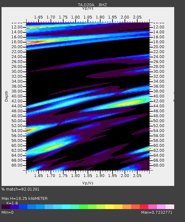
| Estimated Moho Depth: |
18.25 km |
| Estimated Crust Vp/Vs: |
1.60 |
| Assumed Crust Vp: |
6.518 km/s |
| Estimated Crust Vs: |
4.074 km/s |
| Estimated Crust Poisson's Ratio: |
0.18 |
|
| Radial Match: |
92.01281 % |
| Radial Bump: |
365 |
| Transverse Match: |
74.70545 % |
| Transverse Bump: |
400 |
| SOD ConfigId: |
2560 |
| Insert Time: |
2010-03-06 21:24:55.185 +0000 |
| GWidth: |
2.5 |
| Max Bumps: |
400 |
| Tol: |
0.001 |
|

Signal To Noise
| Channel | StoN | STA | LTA |
| TA:D20A: :BHZ:20080911T00:31:34.700029Z | 5.015136 | 1.2400982E-6 | 2.4727112E-7 |
| TA:D20A: :BHN:20080911T00:31:34.700029Z | 0.8635833 | 3.2309455E-7 | 3.7413247E-7 |
| TA:D20A: :BHE:20080911T00:31:34.700029Z | 1.1168131 | 4.455325E-7 | 3.98932E-7 |
| Arrivals |
| Ps | 1.8 SECOND |
| PpPs | 7.0 SECOND |
| PsPs/PpSs | 8.7 SECOND |


