You are here: Home > Network List > TS - TERRAscope (Southern California Seismic Network) Stations List
> Station DGR Domenigoni Valley Reservior, California, USA > Earthquake Result Viewer
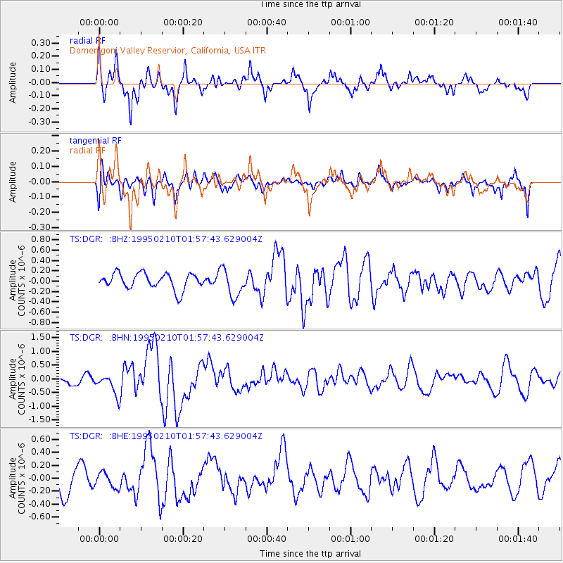
DGR Domenigoni Valley Reservior, California, USA - Earthquake Result Viewer
*The percent match for this event was below the threshold and hence no stack was calculated.
| Earthquake location: |
Off E. Coast Of N. Island, N.Z. |
| Earthquake latitude/longitude: |
-38.0/178.5 |
| Earthquake time(UTC): |
1995/02/10 (041) 01:45:04 GMT |
| Earthquake Depth: |
33 km |
| Earthquake Magnitude: |
5.8 MB, 6.4 MS, 6.5 UNKNOWN, 6.3 ML |
| Earthquake Catalog/Contributor: |
WHDF/NEIC |
|
| Network: |
TS TERRAscope (Southern California Seismic Network) |
| Station: |
DGR Domenigoni Valley Reservior, California, USA |
| Lat/Lon: |
33.65 N/117.01 W |
| Elevation: |
700 m |
|
| Distance: |
93.1 deg |
| Az: |
48.949 deg |
| Baz: |
225.604 deg |
| Ray Param: |
$rayparam |
*The percent match for this event was below the threshold and hence was not used in the summary stack. |
|
| Radial Match: |
78.97331 % |
| Radial Bump: |
397 |
| Transverse Match: |
62.32167 % |
| Transverse Bump: |
400 |
| SOD ConfigId: |
4480 |
| Insert Time: |
2010-02-26 14:10:21.332 +0000 |
| GWidth: |
2.5 |
| Max Bumps: |
400 |
| Tol: |
0.001 |
|
Signal To Noise
| Channel | StoN | STA | LTA |
| TS:DGR: :BHN:19950210T01:57:43.629004Z | 3.0275106 | 3.967362E-7 | 1.310437E-7 |
| TS:DGR: :BHE:19950210T01:57:43.629004Z | 0.6092596 | 1.1793206E-7 | 1.9356618E-7 |
| TS:DGR: :BHZ:19950210T01:57:43.629004Z | 1.7831115 | 2.7253157E-7 | 1.5284046E-7 |
| Arrivals |
| Ps | |
| PpPs | |
| PsPs/PpSs | |


