You are here: Home > Network List > TA - USArray Transportable Network (new EarthScope stations) Stations List
> Station D20A Manuel Ranch, Winnett, MT, USA > Earthquake Result Viewer
D20A Manuel Ranch, Winnett, MT, USA - Earthquake Result Viewer
| Earthquake location: |
Southwestern Ryukyu Isl., Japan |
| Earthquake latitude/longitude: |
23.5/123.5 |
| Earthquake time(UTC): |
2009/08/17 (229) 00:05:49 GMT |
| Earthquake Depth: |
20 km |
| Earthquake Magnitude: |
6.2 MB, 6.6 MS, 6.7 MW, 6.6 MW |
| Earthquake Catalog/Contributor: |
WHDF/NEIC |
|
| Network: |
TA USArray Transportable Network (new EarthScope stations) |
| Station: |
D20A Manuel Ranch, Winnett, MT, USA |
| Lat/Lon: |
47.09 N/108.14 W |
| Elevation: |
902 m |
|
| Distance: |
95.7 deg |
| Az: |
32.577 deg |
| Baz: |
313.663 deg |
| Ray Param: |
0.040699422 |
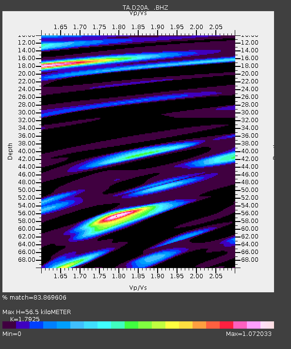
| Estimated Moho Depth: |
56.5 km |
| Estimated Crust Vp/Vs: |
1.79 |
| Assumed Crust Vp: |
6.518 km/s |
| Estimated Crust Vs: |
3.637 km/s |
| Estimated Crust Poisson's Ratio: |
0.27 |
|
| Radial Match: |
83.869606 % |
| Radial Bump: |
400 |
| Transverse Match: |
77.59037 % |
| Transverse Bump: |
400 |
| SOD ConfigId: |
2622 |
| Insert Time: |
2010-03-06 21:25:13.970 +0000 |
| GWidth: |
2.5 |
| Max Bumps: |
400 |
| Tol: |
0.001 |
|
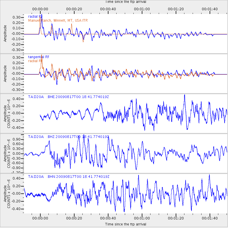
Signal To Noise
| Channel | StoN | STA | LTA |
| TA:D20A: :BHZ:20090817T00:18:41.774019Z | 4.1289577 | 3.1350802E-7 | 7.5929094E-8 |
| TA:D20A: :BHN:20090817T00:18:41.774019Z | 1.0550827 | 8.3304975E-8 | 7.895588E-8 |
| TA:D20A: :BHE:20090817T00:18:41.774019Z | 1.5029908 | 1.0770675E-7 | 7.166162E-8 |
| Arrivals |
| Ps | 7.0 SECOND |
| PpPs | 24 SECOND |
| PsPs/PpSs | 31 SECOND |


