You are here: Home > Network List > BL - Brazilian Lithospheric Seismic Project (BLSP) Stations List
> Station PMNB Patos de Minas, MG > Earthquake Result Viewer
PMNB Patos de Minas, MG - Earthquake Result Viewer
| Earthquake location: |
South Sandwich Islands Region |
| Earthquake latitude/longitude: |
-58.6/-25.3 |
| Earthquake time(UTC): |
2019/04/09 (099) 17:53:59 GMT |
| Earthquake Depth: |
46 km |
| Earthquake Magnitude: |
6.5 Mww |
| Earthquake Catalog/Contributor: |
NEIC PDE/us |
|
| Network: |
BL Brazilian Lithospheric Seismic Project (BLSP) |
| Station: |
PMNB Patos de Minas, MG |
| Lat/Lon: |
18.54 S/46.44 W |
| Elevation: |
950 m |
|
| Distance: |
42.9 deg |
| Az: |
329.793 deg |
| Baz: |
163.877 deg |
| Ray Param: |
0.07277993 |
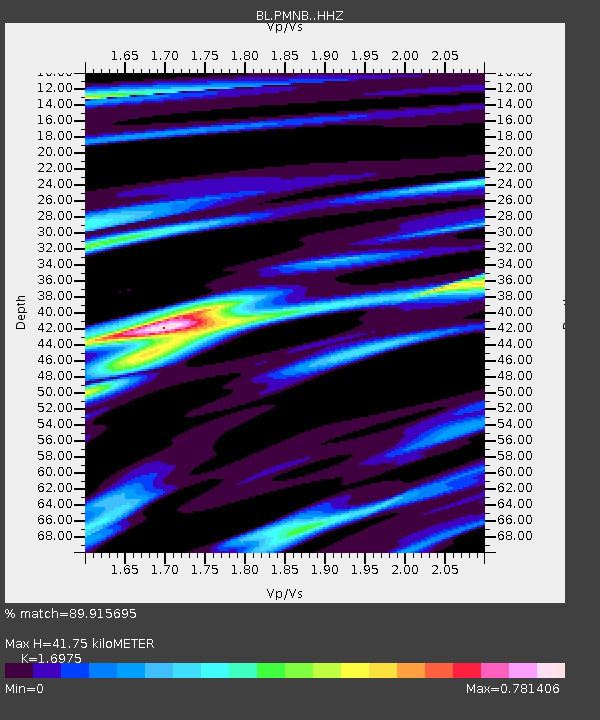
| Estimated Moho Depth: |
41.75 km |
| Estimated Crust Vp/Vs: |
1.70 |
| Assumed Crust Vp: |
6.419 km/s |
| Estimated Crust Vs: |
3.782 km/s |
| Estimated Crust Poisson's Ratio: |
0.23 |
|
| Radial Match: |
89.915695 % |
| Radial Bump: |
244 |
| Transverse Match: |
67.63293 % |
| Transverse Bump: |
400 |
| SOD ConfigId: |
13570011 |
| Insert Time: |
2019-05-02 22:01:36.423 +0000 |
| GWidth: |
2.5 |
| Max Bumps: |
400 |
| Tol: |
0.001 |
|

Signal To Noise
| Channel | StoN | STA | LTA |
| BL:PMNB: :HHZ:20190409T18:01:22.820006Z | 14.874234 | 6.8326553E-6 | 4.5936181E-7 |
| BL:PMNB: :HHN:20190409T18:01:22.820006Z | 11.880027 | 3.958844E-6 | 3.332353E-7 |
| BL:PMNB: :HHE:20190409T18:01:22.820006Z | 4.8209977 | 1.4965099E-6 | 3.1041498E-7 |
| Arrivals |
| Ps | 4.9 SECOND |
| PpPs | 16 SECOND |
| PsPs/PpSs | 21 SECOND |


