You are here: Home > Network List > ON - RSIS-Rede Sismografica do Sul e Sudeste Observatorio Nacional, Brazil Stations List
> Station GUA01 "OBSN: [GUA01] Guaratinga, BA" > Earthquake Result Viewer
GUA01 "OBSN: [GUA01] Guaratinga, BA" - Earthquake Result Viewer
| Earthquake location: |
South Sandwich Islands Region |
| Earthquake latitude/longitude: |
-58.6/-25.3 |
| Earthquake time(UTC): |
2019/04/09 (099) 17:53:59 GMT |
| Earthquake Depth: |
46 km |
| Earthquake Magnitude: |
6.5 Mww |
| Earthquake Catalog/Contributor: |
NEIC PDE/us |
|
| Network: |
ON RSIS-Rede Sismografica do Sul e Sudeste Observatorio Nacional, Brazil |
| Station: |
GUA01 "OBSN: [GUA01] Guaratinga, BA" |
| Lat/Lon: |
16.58 S/39.81 W |
| Elevation: |
198 m |
|
| Distance: |
43.3 deg |
| Az: |
339.472 deg |
| Baz: |
168.96 deg |
| Ray Param: |
0.07252103 |
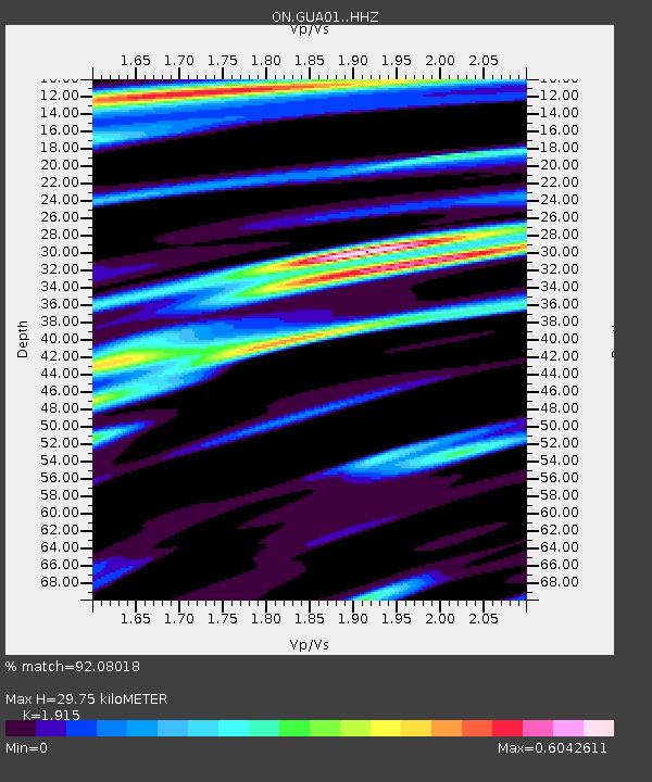
| Estimated Moho Depth: |
29.75 km |
| Estimated Crust Vp/Vs: |
1.91 |
| Assumed Crust Vp: |
6.391 km/s |
| Estimated Crust Vs: |
3.337 km/s |
| Estimated Crust Poisson's Ratio: |
0.31 |
|
| Radial Match: |
92.08018 % |
| Radial Bump: |
313 |
| Transverse Match: |
81.486145 % |
| Transverse Bump: |
400 |
| SOD ConfigId: |
13570011 |
| Insert Time: |
2019-05-02 22:02:55.715 +0000 |
| GWidth: |
2.5 |
| Max Bumps: |
400 |
| Tol: |
0.001 |
|

Signal To Noise
| Channel | StoN | STA | LTA |
| ON:GUA01: :HHZ:20190409T18:01:26.078001Z | 17.56319 | 4.5075285E-6 | 2.5664633E-7 |
| ON:GUA01: :HHN:20190409T18:01:26.078001Z | 11.29714 | 2.3488192E-6 | 2.0791272E-7 |
| ON:GUA01: :HHE:20190409T18:01:26.078001Z | 4.294943 | 6.448169E-7 | 1.50134E-7 |
| Arrivals |
| Ps | 4.5 SECOND |
| PpPs | 13 SECOND |
| PsPs/PpSs | 17 SECOND |


