You are here: Home > Network List > TA - USArray Transportable Network (new EarthScope stations) Stations List
> Station D20A Manuel Ranch, Winnett, MT, USA > Earthquake Result Viewer
D20A Manuel Ranch, Winnett, MT, USA - Earthquake Result Viewer
| Earthquake location: |
Tonga Islands Region |
| Earthquake latitude/longitude: |
-23.0/-174.7 |
| Earthquake time(UTC): |
2009/03/19 (078) 18:17:40 GMT |
| Earthquake Depth: |
34 km |
| Earthquake Magnitude: |
7.0 MB, 7.6 MS, 7.6 MW, 7.6 MW |
| Earthquake Catalog/Contributor: |
WHDF/NEIC |
|
| Network: |
TA USArray Transportable Network (new EarthScope stations) |
| Station: |
D20A Manuel Ranch, Winnett, MT, USA |
| Lat/Lon: |
47.09 N/108.14 W |
| Elevation: |
902 m |
|
| Distance: |
91.9 deg |
| Az: |
38.834 deg |
| Baz: |
237.71 deg |
| Ray Param: |
0.0415282 |
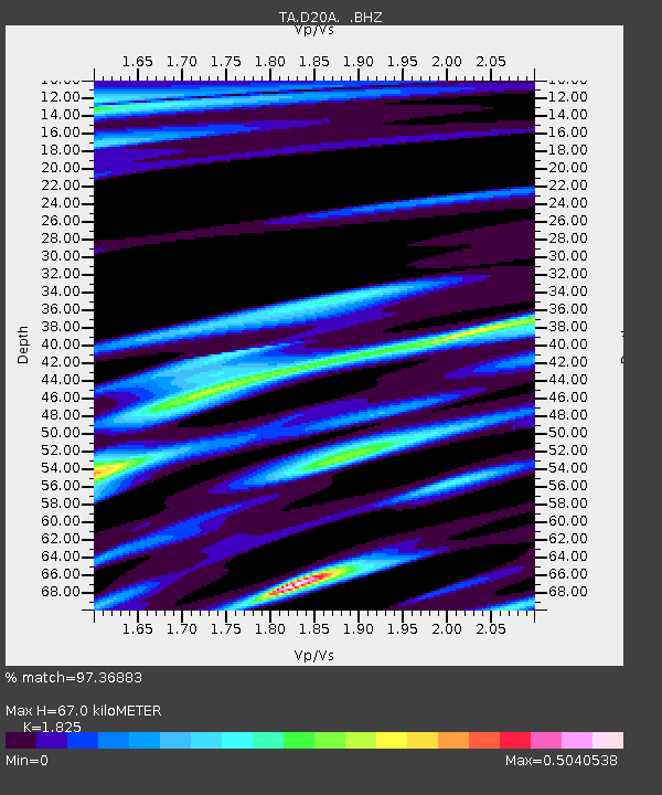
| Estimated Moho Depth: |
67.0 km |
| Estimated Crust Vp/Vs: |
1.83 |
| Assumed Crust Vp: |
6.518 km/s |
| Estimated Crust Vs: |
3.572 km/s |
| Estimated Crust Poisson's Ratio: |
0.29 |
|
| Radial Match: |
97.36883 % |
| Radial Bump: |
400 |
| Transverse Match: |
82.05129 % |
| Transverse Bump: |
400 |
| SOD ConfigId: |
2658 |
| Insert Time: |
2010-03-06 21:25:56.301 +0000 |
| GWidth: |
2.5 |
| Max Bumps: |
400 |
| Tol: |
0.001 |
|

Signal To Noise
| Channel | StoN | STA | LTA |
| TA:D20A: :BHZ:20090319T18:30:14.524014Z | 18.6439 | 4.150634E-6 | 2.2262691E-7 |
| TA:D20A: :BHN:20090319T18:30:14.524014Z | 5.9965477 | 7.2562455E-7 | 1.2100705E-7 |
| TA:D20A: :BHE:20090319T18:30:14.524014Z | 7.59652 | 1.1441356E-6 | 1.5061312E-7 |
| Arrivals |
| Ps | 8.7 SECOND |
| PpPs | 28 SECOND |
| PsPs/PpSs | 37 SECOND |


