You are here: Home > Network List > PR - Puerto Rico Seismic Network (PRSN) & Puerto Rico Strong Motion Program (PRSMP) Stations List
> Station CELP Cerrilos Dam > Earthquake Result Viewer
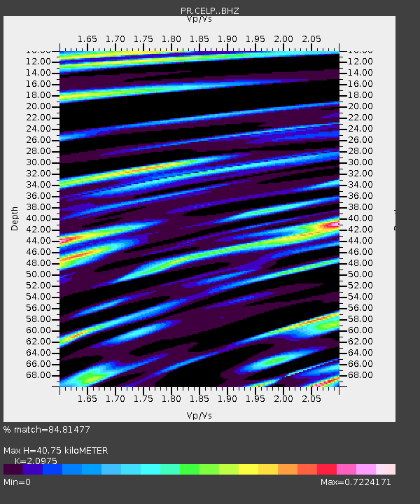
CELP Cerrilos Dam - Earthquake Result Viewer
| Earthquake location: |
South Sandwich Islands Region |
| Earthquake latitude/longitude: |
-58.6/-25.3 |
| Earthquake time(UTC): |
2019/04/09 (099) 17:53:59 GMT |
| Earthquake Depth: |
46 km |
| Earthquake Magnitude: |
6.5 Mww |
| Earthquake Catalog/Contributor: |
NEIC PDE/us |
|
| Network: |
PR Puerto Rico Seismic Network (PRSN) & Puerto Rico Strong Motion Program (PRSMP) |
| Station: |
CELP Cerrilos Dam |
| Lat/Lon: |
18.07 N/66.58 W |
| Elevation: |
196 m |
|
| Distance: |
83.6 deg |
| Az: |
320.82 deg |
| Baz: |
159.648 deg |
| Ray Param: |
0.045998972 |
| Estimated Moho Depth: |
40.75 km |
| Estimated Crust Vp/Vs: |
2.10 |
| Assumed Crust Vp: |
5.14 km/s |
| Estimated Crust Vs: |
2.451 km/s |
| Estimated Crust Poisson's Ratio: |
0.35 |
|
| Radial Match: |
84.81477 % |
| Radial Bump: |
400 |
| Transverse Match: |
77.8264 % |
| Transverse Bump: |
400 |
| SOD ConfigId: |
13570011 |
| Insert Time: |
2019-05-02 22:03:14.283 +0000 |
| GWidth: |
2.5 |
| Max Bumps: |
400 |
| Tol: |
0.001 |
|

Signal To Noise
| Channel | StoN | STA | LTA |
| PR:CELP: :BHZ:20190409T18:05:51.535002Z | 13.578848 | 2.7439607E-6 | 2.020761E-7 |
| PR:CELP: :BHN:20190409T18:05:51.535002Z | 5.2026267 | 5.9392534E-7 | 1.14158745E-7 |
| PR:CELP: :BHE:20190409T18:05:51.535002Z | 2.8594441 | 3.8138356E-7 | 1.3337682E-7 |
| Arrivals |
| Ps | 8.8 SECOND |
| PpPs | 24 SECOND |
| PsPs/PpSs | 33 SECOND |


