You are here: Home > Network List > TA - USArray Transportable Network (new EarthScope stations) Stations List
> Station D20A Manuel Ranch, Winnett, MT, USA > Earthquake Result Viewer
D20A Manuel Ranch, Winnett, MT, USA - Earthquake Result Viewer

| Earthquake location: |
Guatemala |
| Earthquake latitude/longitude: |
14.6/-91.2 |
| Earthquake time(UTC): |
2009/05/03 (123) 16:21:47 GMT |
| Earthquake Depth: |
124 km |
| Earthquake Magnitude: |
5.6 MB, 6.2 MW, 6.2 MW |
| Earthquake Catalog/Contributor: |
WHDF/NEIC |
|
| Network: |
TA USArray Transportable Network (new EarthScope stations) |
| Station: |
D20A Manuel Ranch, Winnett, MT, USA |
| Lat/Lon: |
47.09 N/108.14 W |
| Elevation: |
902 m |
|
| Distance: |
35.4 deg |
| Az: |
339.856 deg |
| Baz: |
150.79 deg |
| Ray Param: |
0.07683592 |
| Estimated Moho Depth: |
13.75 km |
| Estimated Crust Vp/Vs: |
1.65 |
| Assumed Crust Vp: |
6.518 km/s |
| Estimated Crust Vs: |
3.945 km/s |
| Estimated Crust Poisson's Ratio: |
0.21 |
|
| Radial Match: |
83.030045 % |
| Radial Bump: |
267 |
| Transverse Match: |
68.44604 % |
| Transverse Bump: |
321 |
| SOD ConfigId: |
2658 |
| Insert Time: |
2010-03-06 21:25:59.853 +0000 |
| GWidth: |
2.5 |
| Max Bumps: |
400 |
| Tol: |
0.001 |
|
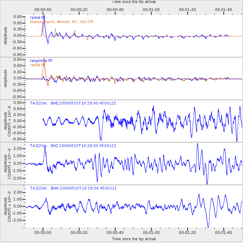
Signal To Noise
| Channel | StoN | STA | LTA |
| TA:D20A: :BHZ:20090503T16:28:00.450012Z | 13.990133 | 9.582415E-7 | 6.849409E-8 |
| TA:D20A: :BHN:20090503T16:28:00.450012Z | 5.2242527 | 6.521716E-7 | 1.2483538E-7 |
| TA:D20A: :BHE:20090503T16:28:00.450012Z | 3.696785 | 4.49828E-7 | 1.2168087E-7 |
| Arrivals |
| Ps | 1.5 SECOND |
| PpPs | 5.1 SECOND |
| PsPs/PpSs | 6.6 SECOND |


