You are here: Home > Network List > PF - Volcanologic Network of Piton de Fournaise-OVPF Stations List
> Station HIM cratere Himiltrude > Earthquake Result Viewer
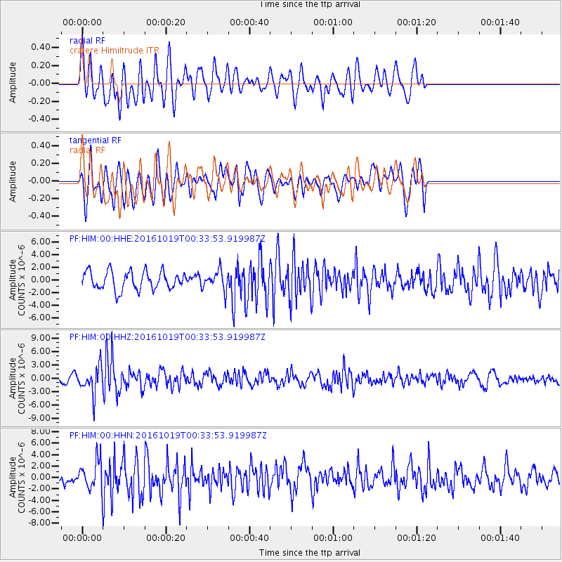
HIM cratere Himiltrude - Earthquake Result Viewer
*The percent match for this event was below the threshold and hence no stack was calculated.
| Earthquake location: |
Java Sea |
| Earthquake latitude/longitude: |
-4.9/108.2 |
| Earthquake time(UTC): |
2016/10/19 (293) 00:26:01 GMT |
| Earthquake Depth: |
614 km |
| Earthquake Magnitude: |
6.6 MWW, 6.6 MWC, 6.7 MWB |
| Earthquake Catalog/Contributor: |
NEIC PDE/NEIC COMCAT |
|
| Network: |
PF Volcanologic Network of Piton de Fournaise-OVPF |
| Station: |
HIM cratere Himiltrude |
| Lat/Lon: |
21.21 S/55.72 E |
| Elevation: |
1958 m |
|
| Distance: |
53.3 deg |
| Az: |
247.227 deg |
| Baz: |
79.956 deg |
| Ray Param: |
$rayparam |
*The percent match for this event was below the threshold and hence was not used in the summary stack. |
|
| Radial Match: |
63.527992 % |
| Radial Bump: |
400 |
| Transverse Match: |
58.885895 % |
| Transverse Bump: |
400 |
| SOD ConfigId: |
1815711 |
| Insert Time: |
2016-11-02 00:28:44.970 +0000 |
| GWidth: |
2.5 |
| Max Bumps: |
400 |
| Tol: |
0.001 |
|
Signal To Noise
| Channel | StoN | STA | LTA |
| PF:HIM:00:HHZ:20161019T00:33:53.919987Z | 3.7873025 | 3.1747695E-6 | 8.3826666E-7 |
| PF:HIM:00:HHN:20161019T00:33:53.919987Z | 2.0874174 | 2.5077093E-6 | 1.2013454E-6 |
| PF:HIM:00:HHE:20161019T00:33:53.919987Z | 1.0562557 | 1.5189754E-6 | 1.4380754E-6 |
| Arrivals |
| Ps | |
| PpPs | |
| PsPs/PpSs | |


