You are here: Home > Network List > TA - USArray Transportable Network (new EarthScope stations) Stations List
> Station D20A Manuel Ranch, Winnett, MT, USA > Earthquake Result Viewer
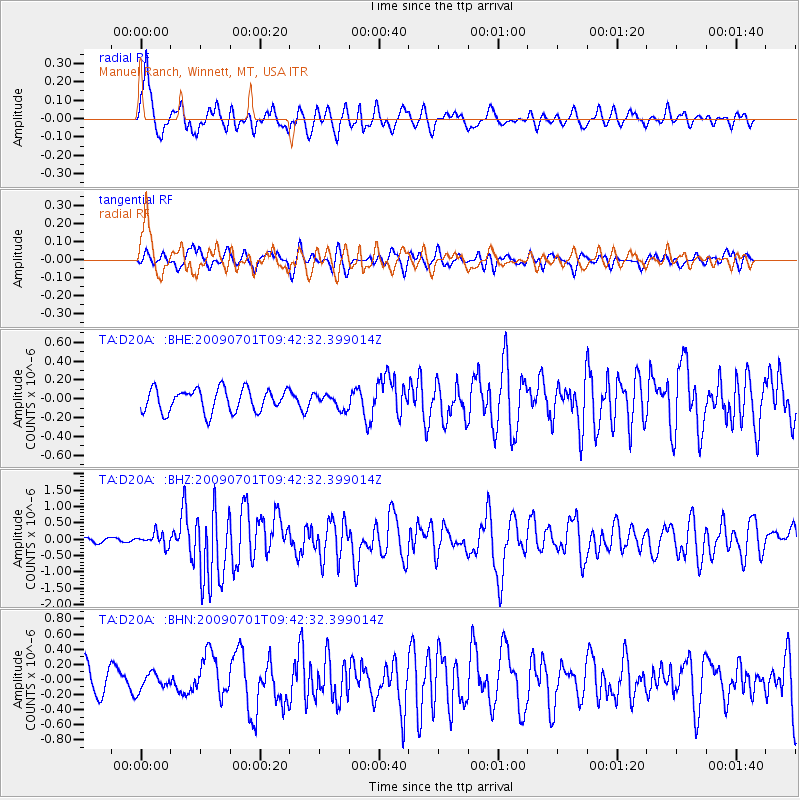
D20A Manuel Ranch, Winnett, MT, USA - Earthquake Result Viewer
*The percent match for this event was below the threshold and hence no stack was calculated.
| Earthquake location: |
Crete, Greece |
| Earthquake latitude/longitude: |
34.2/25.5 |
| Earthquake time(UTC): |
2009/07/01 (182) 09:30:10 GMT |
| Earthquake Depth: |
19 km |
| Earthquake Magnitude: |
6.1 MB, 6.3 MS, 6.4 MW, 6.4 MW |
| Earthquake Catalog/Contributor: |
WHDF/NEIC |
|
| Network: |
TA USArray Transportable Network (new EarthScope stations) |
| Station: |
D20A Manuel Ranch, Winnett, MT, USA |
| Lat/Lon: |
47.09 N/108.14 W |
| Elevation: |
902 m |
|
| Distance: |
89.0 deg |
| Az: |
330.341 deg |
| Baz: |
36.905 deg |
| Ray Param: |
$rayparam |
*The percent match for this event was below the threshold and hence was not used in the summary stack. |
|
| Radial Match: |
79.247055 % |
| Radial Bump: |
400 |
| Transverse Match: |
57.25761 % |
| Transverse Bump: |
400 |
| SOD ConfigId: |
2622 |
| Insert Time: |
2010-03-06 21:26:31.281 +0000 |
| GWidth: |
2.5 |
| Max Bumps: |
400 |
| Tol: |
0.001 |
|
Signal To Noise
| Channel | StoN | STA | LTA |
| TA:D20A: :BHZ:20090701T09:42:32.399014Z | 2.4683619 | 1.9077171E-7 | 7.728677E-8 |
| TA:D20A: :BHN:20090701T09:42:32.399014Z | 0.5907272 | 1.1094823E-7 | 1.8781635E-7 |
| TA:D20A: :BHE:20090701T09:42:32.399014Z | 0.63238573 | 7.7099166E-8 | 1.2191795E-7 |
| Arrivals |
| Ps | |
| PpPs | |
| PsPs/PpSs | |


