You are here: Home > Network List > TA - USArray Transportable Network (new EarthScope stations) Stations List
> Station A19K Wainwright, AK, USA > Earthquake Result Viewer
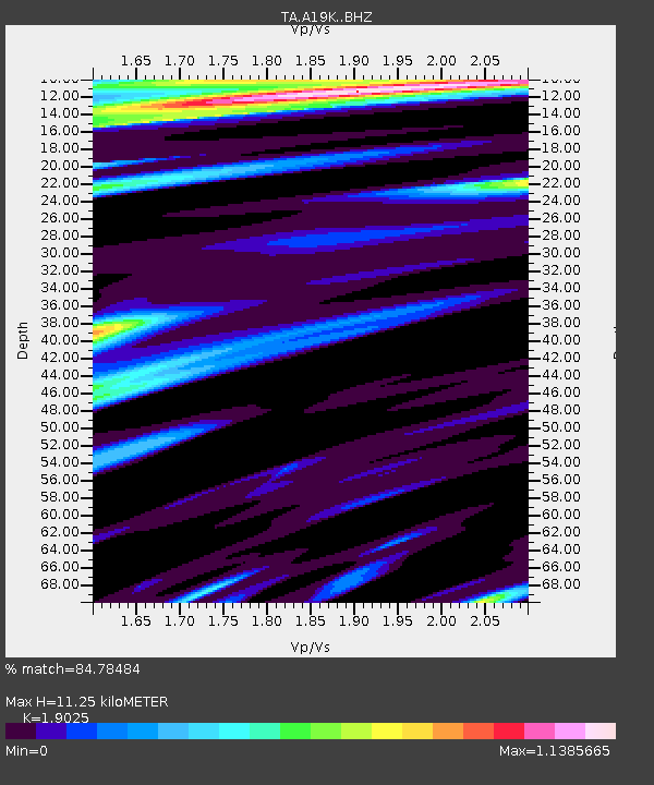
A19K Wainwright, AK, USA - Earthquake Result Viewer
| Earthquake location: |
Off East Coast Of Honshu, Japan |
| Earthquake latitude/longitude: |
40.4/143.3 |
| Earthquake time(UTC): |
2019/04/11 (101) 08:18:20 GMT |
| Earthquake Depth: |
12 km |
| Earthquake Magnitude: |
6.1 Mww |
| Earthquake Catalog/Contributor: |
NEIC PDE/us |
|
| Network: |
TA USArray Transportable Network (new EarthScope stations) |
| Station: |
A19K Wainwright, AK, USA |
| Lat/Lon: |
70.20 N/161.07 W |
| Elevation: |
24 m |
|
| Distance: |
41.1 deg |
| Az: |
25.348 deg |
| Baz: |
253.618 deg |
| Ray Param: |
0.07402485 |
| Estimated Moho Depth: |
11.25 km |
| Estimated Crust Vp/Vs: |
1.90 |
| Assumed Crust Vp: |
5.989 km/s |
| Estimated Crust Vs: |
3.148 km/s |
| Estimated Crust Poisson's Ratio: |
0.31 |
|
| Radial Match: |
84.78484 % |
| Radial Bump: |
400 |
| Transverse Match: |
58.67286 % |
| Transverse Bump: |
400 |
| SOD ConfigId: |
13570011 |
| Insert Time: |
2019-05-02 22:11:11.644 +0000 |
| GWidth: |
2.5 |
| Max Bumps: |
400 |
| Tol: |
0.001 |
|

Signal To Noise
| Channel | StoN | STA | LTA |
| TA:A19K: :BHZ:20190411T08:25:32.874989Z | 3.8390353 | 6.201077E-7 | 1.6152697E-7 |
| TA:A19K: :BHN:20190411T08:25:32.874989Z | 0.6324349 | 1.1228273E-7 | 1.7754037E-7 |
| TA:A19K: :BHE:20190411T08:25:32.874989Z | 1.9286314 | 3.7886093E-7 | 1.964403E-7 |
| Arrivals |
| Ps | 1.8 SECOND |
| PpPs | 5.2 SECOND |
| PsPs/PpSs | 7.0 SECOND |


