You are here: Home > Network List > TA - USArray Transportable Network (new EarthScope stations) Stations List
> Station D25K Kavik River, AK, USA > Earthquake Result Viewer
D25K Kavik River, AK, USA - Earthquake Result Viewer
| Earthquake location: |
Off East Coast Of Honshu, Japan |
| Earthquake latitude/longitude: |
40.4/143.3 |
| Earthquake time(UTC): |
2019/04/11 (101) 08:18:20 GMT |
| Earthquake Depth: |
12 km |
| Earthquake Magnitude: |
6.1 Mww |
| Earthquake Catalog/Contributor: |
NEIC PDE/us |
|
| Network: |
TA USArray Transportable Network (new EarthScope stations) |
| Station: |
D25K Kavik River, AK, USA |
| Lat/Lon: |
69.32 N/146.38 W |
| Elevation: |
770 m |
|
| Distance: |
46.0 deg |
| Az: |
27.722 deg |
| Baz: |
269.129 deg |
| Ray Param: |
0.07092954 |
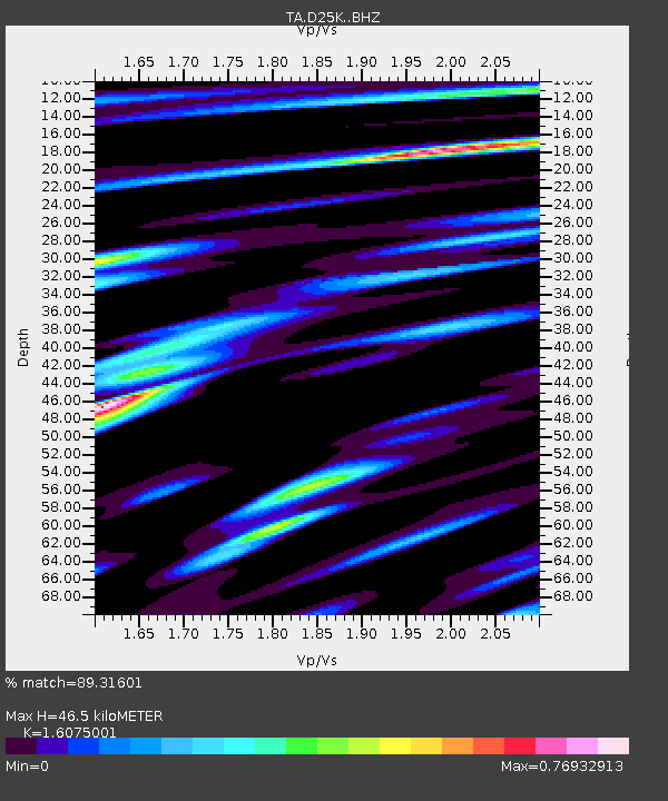
| Estimated Moho Depth: |
46.5 km |
| Estimated Crust Vp/Vs: |
1.61 |
| Assumed Crust Vp: |
6.378 km/s |
| Estimated Crust Vs: |
3.968 km/s |
| Estimated Crust Poisson's Ratio: |
0.18 |
|
| Radial Match: |
89.31601 % |
| Radial Bump: |
400 |
| Transverse Match: |
76.894485 % |
| Transverse Bump: |
400 |
| SOD ConfigId: |
13570011 |
| Insert Time: |
2019-05-02 22:11:26.100 +0000 |
| GWidth: |
2.5 |
| Max Bumps: |
400 |
| Tol: |
0.001 |
|
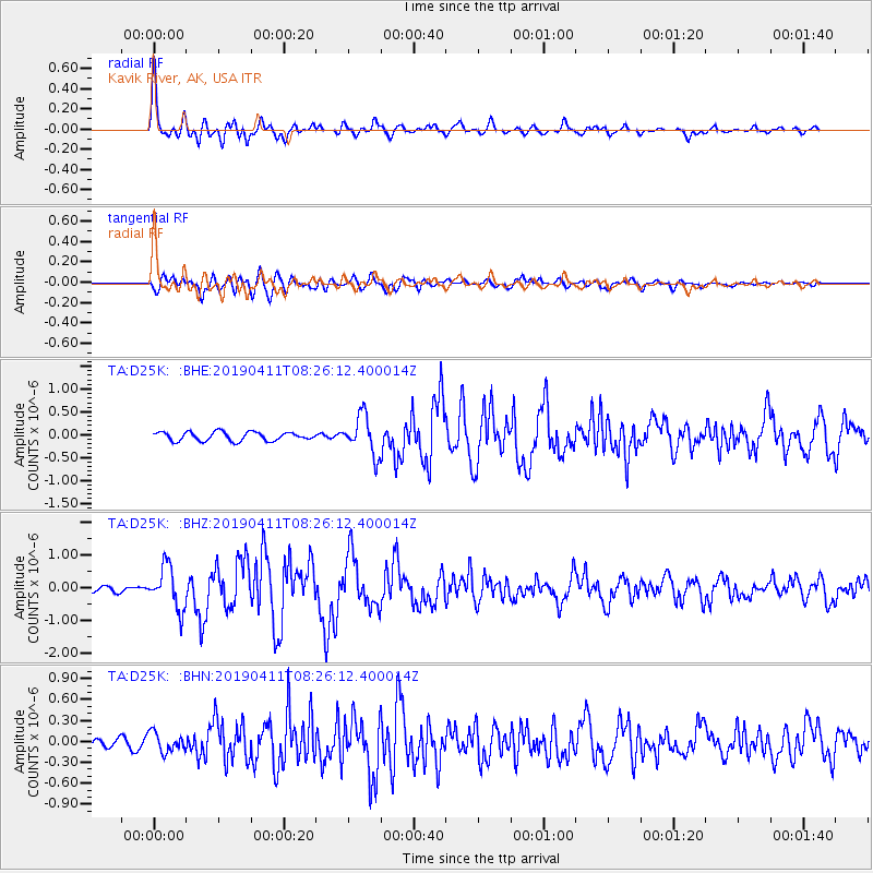
Signal To Noise
| Channel | StoN | STA | LTA |
| TA:D25K: :BHZ:20190411T08:26:12.400014Z | 5.7795568 | 6.3630864E-7 | 1.1009645E-7 |
| TA:D25K: :BHN:20190411T08:26:12.400014Z | 1.048642 | 1.3895018E-7 | 1.3250487E-7 |
| TA:D25K: :BHE:20190411T08:26:12.400014Z | 4.4325414 | 4.225146E-7 | 9.5321084E-8 |
| Arrivals |
| Ps | 4.7 SECOND |
| PpPs | 18 SECOND |
| PsPs/PpSs | 22 SECOND |


