You are here: Home > Network List > TA - USArray Transportable Network (new EarthScope stations) Stations List
> Station G31M Satah River, YT, CAN > Earthquake Result Viewer
G31M Satah River, YT, CAN - Earthquake Result Viewer
| Earthquake location: |
Off East Coast Of Honshu, Japan |
| Earthquake latitude/longitude: |
40.4/143.3 |
| Earthquake time(UTC): |
2019/04/11 (101) 08:18:20 GMT |
| Earthquake Depth: |
12 km |
| Earthquake Magnitude: |
6.1 Mww |
| Earthquake Catalog/Contributor: |
NEIC PDE/us |
|
| Network: |
TA USArray Transportable Network (new EarthScope stations) |
| Station: |
G31M Satah River, YT, CAN |
| Lat/Lon: |
66.92 N/134.27 W |
| Elevation: |
61 m |
|
| Distance: |
50.7 deg |
| Az: |
30.324 deg |
| Baz: |
282.09 deg |
| Ray Param: |
0.067866325 |
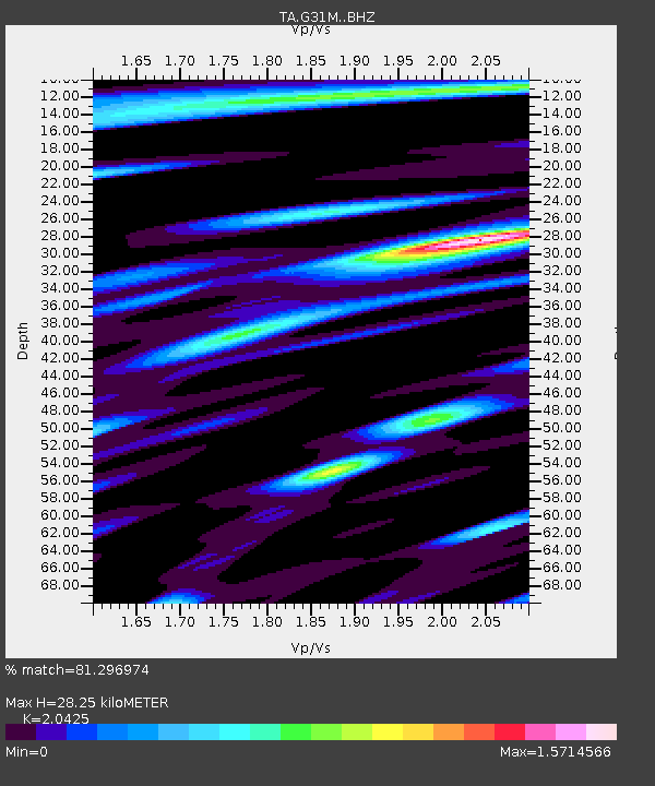
| Estimated Moho Depth: |
28.25 km |
| Estimated Crust Vp/Vs: |
2.04 |
| Assumed Crust Vp: |
6.171 km/s |
| Estimated Crust Vs: |
3.022 km/s |
| Estimated Crust Poisson's Ratio: |
0.34 |
|
| Radial Match: |
81.296974 % |
| Radial Bump: |
400 |
| Transverse Match: |
66.85011 % |
| Transverse Bump: |
400 |
| SOD ConfigId: |
13570011 |
| Insert Time: |
2019-05-02 22:11:53.323 +0000 |
| GWidth: |
2.5 |
| Max Bumps: |
400 |
| Tol: |
0.001 |
|
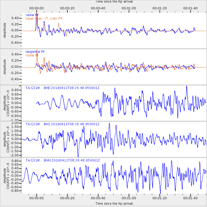
Signal To Noise
| Channel | StoN | STA | LTA |
| TA:G31M: :BHZ:20190411T08:26:48.950001Z | 2.68055 | 5.902334E-7 | 2.2019115E-7 |
| TA:G31M: :BHN:20190411T08:26:48.950001Z | 0.5689672 | 1.2653452E-7 | 2.2239333E-7 |
| TA:G31M: :BHE:20190411T08:26:48.950001Z | 0.6870158 | 1.5832205E-7 | 2.3044893E-7 |
| Arrivals |
| Ps | 5.0 SECOND |
| PpPs | 13 SECOND |
| PsPs/PpSs | 18 SECOND |


