You are here: Home > Network List > TA - USArray Transportable Network (new EarthScope stations) Stations List
> Station C16K Lisburne Hills, AK, USA > Earthquake Result Viewer
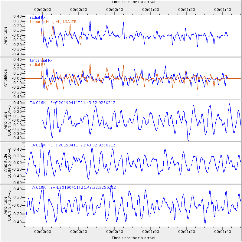
C16K Lisburne Hills, AK, USA - Earthquake Result Viewer
*The percent match for this event was below the threshold and hence no stack was calculated.
| Earthquake location: |
New Britain Region, P.N.G. |
| Earthquake latitude/longitude: |
-6.5/148.7 |
| Earthquake time(UTC): |
2019/04/11 (101) 21:31:50 GMT |
| Earthquake Depth: |
22 km |
| Earthquake Magnitude: |
5.6 Mww |
| Earthquake Catalog/Contributor: |
NEIC PDE/us |
|
| Network: |
TA USArray Transportable Network (new EarthScope stations) |
| Station: |
C16K Lisburne Hills, AK, USA |
| Lat/Lon: |
68.27 N/165.34 W |
| Elevation: |
102 m |
|
| Distance: |
81.2 deg |
| Az: |
15.722 deg |
| Baz: |
226.318 deg |
| Ray Param: |
$rayparam |
*The percent match for this event was below the threshold and hence was not used in the summary stack. |
|
| Radial Match: |
79.35247 % |
| Radial Bump: |
400 |
| Transverse Match: |
59.553192 % |
| Transverse Bump: |
400 |
| SOD ConfigId: |
13570011 |
| Insert Time: |
2019-05-02 22:17:29.053 +0000 |
| GWidth: |
2.5 |
| Max Bumps: |
400 |
| Tol: |
0.001 |
|
Signal To Noise
| Channel | StoN | STA | LTA |
| TA:C16K: :BHZ:20190411T21:43:32.925021Z | 1.8653222 | 3.4526883E-7 | 1.8509877E-7 |
| TA:C16K: :BHN:20190411T21:43:32.925021Z | 1.6410671 | 2.6818793E-7 | 1.6342288E-7 |
| TA:C16K: :BHE:20190411T21:43:32.925021Z | 0.95779896 | 1.5388835E-7 | 1.6066875E-7 |
| Arrivals |
| Ps | |
| PpPs | |
| PsPs/PpSs | |


