You are here: Home > Network List > TA - USArray Transportable Network (new EarthScope stations) Stations List
> Station D20A Manuel Ranch, Winnett, MT, USA > Earthquake Result Viewer
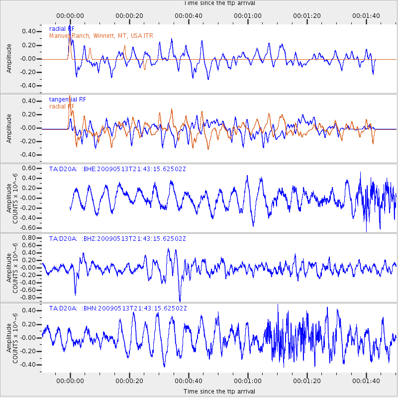
D20A Manuel Ranch, Winnett, MT, USA - Earthquake Result Viewer
*The percent match for this event was below the threshold and hence no stack was calculated.
| Earthquake location: |
Tonga Islands |
| Earthquake latitude/longitude: |
-15.8/-173.5 |
| Earthquake time(UTC): |
2009/05/13 (133) 21:31:17 GMT |
| Earthquake Depth: |
85 km |
| Earthquake Magnitude: |
5.8 MW, 5.3 MB, 5.8 MW |
| Earthquake Catalog/Contributor: |
WHDF/NEIC |
|
| Network: |
TA USArray Transportable Network (new EarthScope stations) |
| Station: |
D20A Manuel Ranch, Winnett, MT, USA |
| Lat/Lon: |
47.09 N/108.14 W |
| Elevation: |
902 m |
|
| Distance: |
85.6 deg |
| Az: |
38.529 deg |
| Baz: |
241.383 deg |
| Ray Param: |
$rayparam |
*The percent match for this event was below the threshold and hence was not used in the summary stack. |
|
| Radial Match: |
64.07448 % |
| Radial Bump: |
400 |
| Transverse Match: |
60.471184 % |
| Transverse Bump: |
400 |
| SOD ConfigId: |
2760 |
| Insert Time: |
2010-03-06 21:27:46.354 +0000 |
| GWidth: |
2.5 |
| Max Bumps: |
400 |
| Tol: |
0.001 |
|
Signal To Noise
| Channel | StoN | STA | LTA |
| TA:D20A: :BHZ:20090513T21:43:15.62502Z | 3.0534768 | 2.5853117E-7 | 8.46678E-8 |
| TA:D20A: :BHN:20090513T21:43:15.62502Z | 0.7831531 | 7.905832E-8 | 1.0094873E-7 |
| TA:D20A: :BHE:20090513T21:43:15.62502Z | 1.1830264 | 1.8993511E-7 | 1.6055019E-7 |
| Arrivals |
| Ps | |
| PpPs | |
| PsPs/PpSs | |


