You are here: Home > Network List > TA - USArray Transportable Network (new EarthScope stations) Stations List
> Station 125A Gardner Draw, Artesia, NM, USA > Earthquake Result Viewer
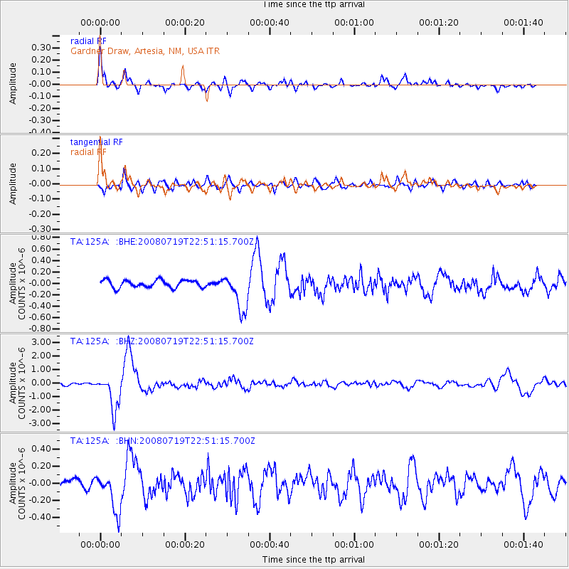
125A Gardner Draw, Artesia, NM, USA - Earthquake Result Viewer

| Earthquake location: |
Fiji Islands Region |
| Earthquake latitude/longitude: |
-17.3/-177.3 |
| Earthquake time(UTC): |
2008/07/19 (201) 22:39:52 GMT |
| Earthquake Depth: |
391 km |
| Earthquake Magnitude: |
5.9 MB, 6.4 MW, 6.4 MW |
| Earthquake Catalog/Contributor: |
WHDF/NEIC |
|
| Network: |
TA USArray Transportable Network (new EarthScope stations) |
| Station: |
125A Gardner Draw, Artesia, NM, USA |
| Lat/Lon: |
32.66 N/104.66 W |
| Elevation: |
1212 m |
|
| Distance: |
85.3 deg |
| Az: |
53.886 deg |
| Baz: |
246.165 deg |
| Ray Param: |
0.043807246 |
| Estimated Moho Depth: |
42.75 km |
| Estimated Crust Vp/Vs: |
1.85 |
| Assumed Crust Vp: |
6.232 km/s |
| Estimated Crust Vs: |
3.364 km/s |
| Estimated Crust Poisson's Ratio: |
0.29 |
|
| Radial Match: |
90.5472 % |
| Radial Bump: |
400 |
| Transverse Match: |
73.20442 % |
| Transverse Bump: |
400 |
| SOD ConfigId: |
2504 |
| Insert Time: |
2010-03-06 21:27:55.367 +0000 |
| GWidth: |
2.5 |
| Max Bumps: |
400 |
| Tol: |
0.001 |
|
Signal To Noise
| Channel | StoN | STA | LTA |
| TA:125A: :BHZ:20080719T22:51:15.700Z | 13.488115 | 1.34678E-6 | 9.984939E-8 |
| TA:125A: :BHN:20080719T22:51:15.700Z | 3.6175127 | 2.4307138E-7 | 6.719296E-8 |
| TA:125A: :BHE:20080719T22:51:15.700Z | 5.203187 | 3.40685E-7 | 6.5476215E-8 |
| Arrivals |
| Ps | 6.0 SECOND |
| PpPs | 19 SECOND |
| PsPs/PpSs | 25 SECOND |


