You are here: Home > Network List > TA - USArray Transportable Network (new EarthScope stations) Stations List
> Station 125A Gardner Draw, Artesia, NM, USA > Earthquake Result Viewer
125A Gardner Draw, Artesia, NM, USA - Earthquake Result Viewer

| Earthquake location: |
Kuril Islands |
| Earthquake latitude/longitude: |
51.0/157.6 |
| Earthquake time(UTC): |
2008/07/24 (206) 01:43:16 GMT |
| Earthquake Depth: |
27 km |
| Earthquake Magnitude: |
6.0 MB, 6.0 MS, 6.2 MW, 6.2 MW |
| Earthquake Catalog/Contributor: |
WHDF/NEIC |
|
| Network: |
TA USArray Transportable Network (new EarthScope stations) |
| Station: |
125A Gardner Draw, Artesia, NM, USA |
| Lat/Lon: |
32.66 N/104.66 W |
| Elevation: |
1212 m |
|
| Distance: |
69.9 deg |
| Az: |
62.894 deg |
| Baz: |
318.143 deg |
| Ray Param: |
0.05531953 |
| Estimated Moho Depth: |
37.25 km |
| Estimated Crust Vp/Vs: |
1.97 |
| Assumed Crust Vp: |
6.232 km/s |
| Estimated Crust Vs: |
3.171 km/s |
| Estimated Crust Poisson's Ratio: |
0.33 |
|
| Radial Match: |
88.76524 % |
| Radial Bump: |
373 |
| Transverse Match: |
69.9564 % |
| Transverse Bump: |
372 |
| SOD ConfigId: |
2504 |
| Insert Time: |
2010-03-06 21:27:58.695 +0000 |
| GWidth: |
2.5 |
| Max Bumps: |
400 |
| Tol: |
0.001 |
|
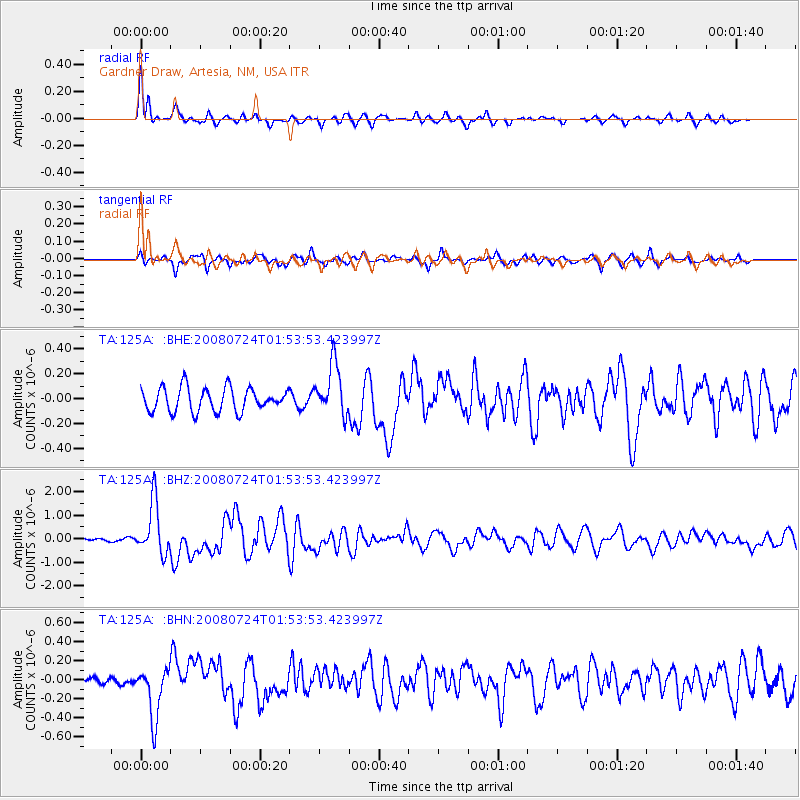
Signal To Noise
| Channel | StoN | STA | LTA |
| TA:125A: :BHZ:20080724T01:53:53.423997Z | 8.249785 | 1.1067932E-6 | 1.3416023E-7 |
| TA:125A: :BHN:20080724T01:53:53.423997Z | 4.1470375 | 2.7465327E-7 | 6.6228786E-8 |
| TA:125A: :BHE:20080724T01:53:53.423997Z | 2.1593013 | 2.0491315E-7 | 9.48979E-8 |
| Arrivals |
| Ps | 6.0 SECOND |
| PpPs | 17 SECOND |
| PsPs/PpSs | 23 SECOND |


