You are here: Home > Network List > TA - USArray Transportable Network (new EarthScope stations) Stations List
> Station 125A Gardner Draw, Artesia, NM, USA > Earthquake Result Viewer
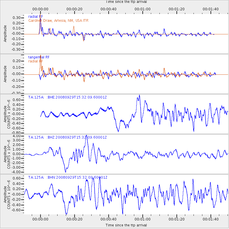
125A Gardner Draw, Artesia, NM, USA - Earthquake Result Viewer
| Earthquake location: |
Kermadec Islands, New Zealand |
| Earthquake latitude/longitude: |
-29.8/-177.7 |
| Earthquake time(UTC): |
2008/09/29 (273) 15:19:31 GMT |
| Earthquake Depth: |
36 km |
| Earthquake Magnitude: |
6.5 MB, 6.7 MS, 7.0 MW, 7.0 MW |
| Earthquake Catalog/Contributor: |
WHDF/NEIC |
|
| Network: |
TA USArray Transportable Network (new EarthScope stations) |
| Station: |
125A Gardner Draw, Artesia, NM, USA |
| Lat/Lon: |
32.66 N/104.66 W |
| Elevation: |
1212 m |
|
| Distance: |
92.9 deg |
| Az: |
53.886 deg |
| Baz: |
236.385 deg |
| Ray Param: |
0.041349307 |
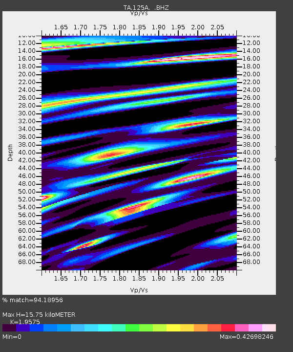
| Estimated Moho Depth: |
15.75 km |
| Estimated Crust Vp/Vs: |
1.96 |
| Assumed Crust Vp: |
6.232 km/s |
| Estimated Crust Vs: |
3.183 km/s |
| Estimated Crust Poisson's Ratio: |
0.32 |
|
| Radial Match: |
94.18956 % |
| Radial Bump: |
400 |
| Transverse Match: |
79.54664 % |
| Transverse Bump: |
400 |
| SOD ConfigId: |
2560 |
| Insert Time: |
2010-03-06 21:28:10.160 +0000 |
| GWidth: |
2.5 |
| Max Bumps: |
400 |
| Tol: |
0.001 |
|
Signal To Noise
| Channel | StoN | STA | LTA |
| TA:125A: :BHZ:20080929T15:32:09.60001Z | 4.976641 | 3.7824276E-7 | 7.600362E-8 |
| TA:125A: :BHN:20080929T15:32:09.60001Z | 0.94585496 | 7.4383735E-8 | 7.86418E-8 |
| TA:125A: :BHE:20080929T15:32:09.60001Z | 1.2945299 | 7.950939E-8 | 6.141951E-8 |
| Arrivals |
| Ps | 2.5 SECOND |
| PpPs | 7.3 SECOND |
| PsPs/PpSs | 9.8 SECOND |


