You are here: Home > Network List > KR - Kyrgyz Digital Network Stations List
> Station SALK Salom-Alik, Kyrgyzstan > Earthquake Result Viewer
SALK Salom-Alik, Kyrgyzstan - Earthquake Result Viewer
| Earthquake location: |
Sulawesi, Indonesia |
| Earthquake latitude/longitude: |
-1.9/122.6 |
| Earthquake time(UTC): |
2019/04/12 (102) 11:40:49 GMT |
| Earthquake Depth: |
17 km |
| Earthquake Magnitude: |
6.8 Mww |
| Earthquake Catalog/Contributor: |
NEIC PDE/us |
|
| Network: |
KR Kyrgyz Digital Network |
| Station: |
SALK Salom-Alik, Kyrgyzstan |
| Lat/Lon: |
40.88 N/73.82 E |
| Elevation: |
1672 m |
|
| Distance: |
61.4 deg |
| Az: |
319.519 deg |
| Baz: |
121.155 deg |
| Ray Param: |
0.060890432 |
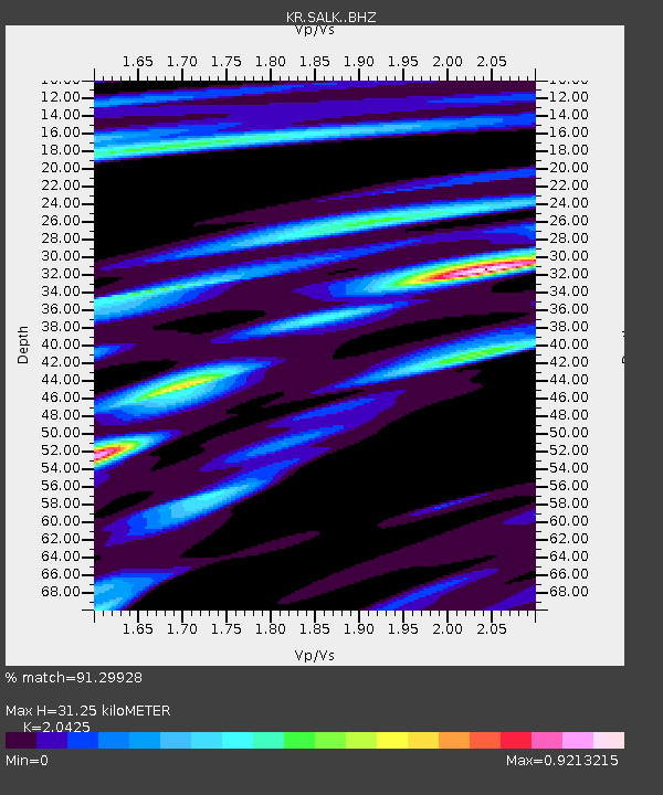
| Estimated Moho Depth: |
31.25 km |
| Estimated Crust Vp/Vs: |
2.04 |
| Assumed Crust Vp: |
6.306 km/s |
| Estimated Crust Vs: |
3.087 km/s |
| Estimated Crust Poisson's Ratio: |
0.34 |
|
| Radial Match: |
91.29928 % |
| Radial Bump: |
256 |
| Transverse Match: |
75.1815 % |
| Transverse Bump: |
400 |
| SOD ConfigId: |
13570011 |
| Insert Time: |
2019-05-02 22:20:58.647 +0000 |
| GWidth: |
2.5 |
| Max Bumps: |
400 |
| Tol: |
0.001 |
|

Signal To Noise
| Channel | StoN | STA | LTA |
| KR:SALK: :BHZ:20190412T11:50:33.719984Z | 13.216057 | 8.706268E-7 | 6.587645E-8 |
| KR:SALK: :BHN:20190412T11:50:33.719984Z | 2.5766914 | 1.6233925E-7 | 6.3002986E-8 |
| KR:SALK: :BHE:20190412T11:50:33.719984Z | 4.4529877 | 3.035542E-7 | 6.816866E-8 |
| Arrivals |
| Ps | 5.4 SECOND |
| PpPs | 15 SECOND |
| PsPs/PpSs | 20 SECOND |


