You are here: Home > Network List > TA - USArray Transportable Network (new EarthScope stations) Stations List
> Station 125A Gardner Draw, Artesia, NM, USA > Earthquake Result Viewer
125A Gardner Draw, Artesia, NM, USA - Earthquake Result Viewer
| Earthquake location: |
Tonga Islands |
| Earthquake latitude/longitude: |
-20.8/-174.3 |
| Earthquake time(UTC): |
2009/07/30 (211) 20:05:34 GMT |
| Earthquake Depth: |
10 km |
| Earthquake Magnitude: |
5.9 MB, 5.7 MS, 5.8 MW, 5.7 MW |
| Earthquake Catalog/Contributor: |
WHDF/NEIC |
|
| Network: |
TA USArray Transportable Network (new EarthScope stations) |
| Station: |
125A Gardner Draw, Artesia, NM, USA |
| Lat/Lon: |
32.66 N/104.66 W |
| Elevation: |
1212 m |
|
| Distance: |
85.1 deg |
| Az: |
52.513 deg |
| Baz: |
241.621 deg |
| Ray Param: |
0.044992194 |
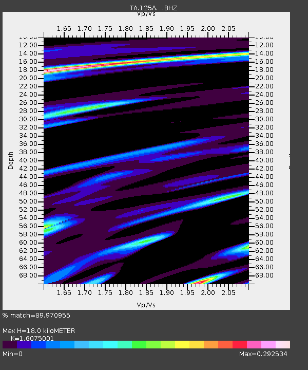
| Estimated Moho Depth: |
18.0 km |
| Estimated Crust Vp/Vs: |
1.61 |
| Assumed Crust Vp: |
6.232 km/s |
| Estimated Crust Vs: |
3.877 km/s |
| Estimated Crust Poisson's Ratio: |
0.18 |
|
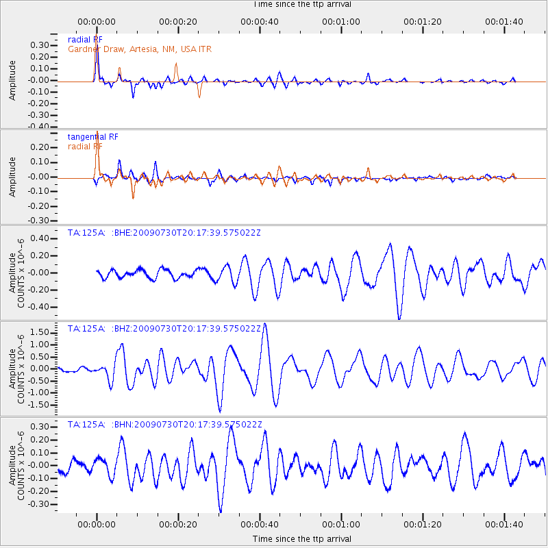
| Radial Match: |
89.970955 % |
| Radial Bump: |
400 |
| Transverse Match: |
81.49161 % |
| Transverse Bump: |
392 |
| SOD ConfigId: |
2622 |
| Insert Time: |
2010-03-06 21:28:14.496 +0000 |
| GWidth: |
2.5 |
| Max Bumps: |
400 |
| Tol: |
0.001 |
|
Signal To Noise
| Channel | StoN | STA | LTA |
| TA:125A: :BHZ:20090730T20:17:39.575022Z | 6.318072 | 3.525536E-7 | 5.580082E-8 |
| TA:125A: :BHN:20090730T20:17:39.575022Z | 1.4484786 | 6.4811964E-8 | 4.4744855E-8 |
| TA:125A: :BHE:20090730T20:17:39.575022Z | 1.9924787 | 9.1673364E-8 | 4.6009706E-8 |
| Arrivals |
| Ps | 1.8 SECOND |
| PpPs | 7.3 SECOND |
| PsPs/PpSs | 9.1 SECOND |


