You are here: Home > Network List > TA - USArray Transportable Network (new EarthScope stations) Stations List
> Station 125A Gardner Draw, Artesia, NM, USA > Earthquake Result Viewer
125A Gardner Draw, Artesia, NM, USA - Earthquake Result Viewer
| Earthquake location: |
Tonga Islands |
| Earthquake latitude/longitude: |
-21.7/-174.6 |
| Earthquake time(UTC): |
2009/08/13 (225) 11:17:01 GMT |
| Earthquake Depth: |
10 km |
| Earthquake Magnitude: |
5.6 MW, 5.3 MB |
| Earthquake Catalog/Contributor: |
WHDF/NEIC |
|
| Network: |
TA USArray Transportable Network (new EarthScope stations) |
| Station: |
125A Gardner Draw, Artesia, NM, USA |
| Lat/Lon: |
32.66 N/104.66 W |
| Elevation: |
1212 m |
|
| Distance: |
85.8 deg |
| Az: |
52.588 deg |
| Baz: |
241.153 deg |
| Ray Param: |
0.044473108 |
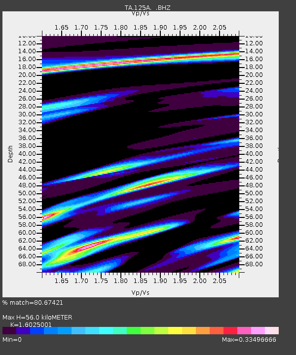
| Estimated Moho Depth: |
56.0 km |
| Estimated Crust Vp/Vs: |
1.60 |
| Assumed Crust Vp: |
6.232 km/s |
| Estimated Crust Vs: |
3.889 km/s |
| Estimated Crust Poisson's Ratio: |
0.18 |
|
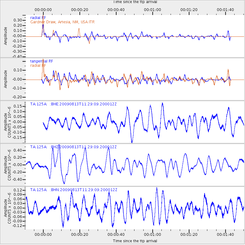
| Radial Match: |
80.67421 % |
| Radial Bump: |
400 |
| Transverse Match: |
53.852318 % |
| Transverse Bump: |
400 |
| SOD ConfigId: |
2622 |
| Insert Time: |
2010-03-06 21:28:21.442 +0000 |
| GWidth: |
2.5 |
| Max Bumps: |
400 |
| Tol: |
0.001 |
|
Signal To Noise
| Channel | StoN | STA | LTA |
| TA:125A: :BHZ:20090813T11:29:09.200012Z | 3.1023912 | 1.6373176E-7 | 5.277598E-8 |
| TA:125A: :BHN:20090813T11:29:09.200012Z | 0.32808104 | 1.2450495E-8 | 3.794945E-8 |
| TA:125A: :BHE:20090813T11:29:09.200012Z | 1.0317827 | 3.752422E-8 | 3.6368334E-8 |
| Arrivals |
| Ps | 5.5 SECOND |
| PpPs | 23 SECOND |
| PsPs/PpSs | 28 SECOND |


